Travel Through Iceland on a Harley-Davidson
By Peter & Kay Forwood
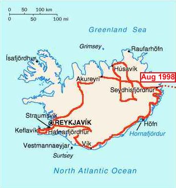
Iceland on a Harley (11/8/98 - 27/8/98)
Distance 2571 km (108260 km to 110831 km)
This is part of the fourth section of our around the
world trip.
Complete Trip Overview & Map
Coming from Norway
 11/8/98 Off to Iceland, that cold country somewhere in the
north west near Greenland, 250,000 inhabitants, settled by Vikings over a
1000 years ago, 80% of the population living in the capital leaving the rest
to the wilds of uninhabited wind swept, rain swept barrenness. Icelanders
have a reputation similar to the Vikings of a fun loving, hard living fearless
people. We boarded the Smyril-Line boat at 3 pm after a relaxed morning ready
for the two day voyage out through the islands surrounding Bergen and into
the foggy (thankfully calm) sea. The vehicle ferry only runs for four months
of the year as no one is stupid enough to holiday in Iceland in winter, even
less likely to face the North Atlantic winter storms.
11/8/98 Off to Iceland, that cold country somewhere in the
north west near Greenland, 250,000 inhabitants, settled by Vikings over a
1000 years ago, 80% of the population living in the capital leaving the rest
to the wilds of uninhabited wind swept, rain swept barrenness. Icelanders
have a reputation similar to the Vikings of a fun loving, hard living fearless
people. We boarded the Smyril-Line boat at 3 pm after a relaxed morning ready
for the two day voyage out through the islands surrounding Bergen and into
the foggy (thankfully calm) sea. The vehicle ferry only runs for four months
of the year as no one is stupid enough to holiday in Iceland in winter, even
less likely to face the North Atlantic winter storms.
12/8/98 Stop off at the Shetland Islands for an hour in
the middle of the night and at the Faroe Islands for three hours this afternoon.
Otherwise the days sailing was reasonable smooth with a chance for reading
and postcards.
13/8/98 At 8 am we started cruising up the 16 km fjord
to the town of Seydisfjordur on the east coast of Iceland. The first notable
trait is the total lack of trees or shrubbery and the thousands of seagulls.
Customs was polite and cursory and we received a special permit to drive
in Iceland. The temperature was 10 degrees and after getting money and posting
cards we climbed up out of the fjord to a plateau (Iceland averages 400m above
sea level) where the temperature dropped to 7 degrees and 15 km later in
the next town with sunshine, was 17 degrees.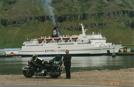 Within 30 minutes the weather had drizzled, rained,
sunshine, strong winds, welcome to Iceland where they say if you don't like
the weather now wait five minutes and it will change. This is where the
Widder Electric gear is
great, dressing for 15 degrees, when colder turn it up and when the temperature
rises again turn it off. 300 km south along the coast to Hofn with more extremes
of heavy rain to sunshine before a wet night in the tent.
Within 30 minutes the weather had drizzled, rained,
sunshine, strong winds, welcome to Iceland where they say if you don't like
the weather now wait five minutes and it will change. This is where the
Widder Electric gear is
great, dressing for 15 degrees, when colder turn it up and when the temperature
rises again turn it off. 300 km south along the coast to Hofn with more extremes
of heavy rain to sunshine before a wet night in the tent.
14/8/98 The weather cleared and from the start of travelling
to the end we were never out of sight of one of the tongues of the glacier
Vatnajokull. This 8400 sq. km glacier dominates the south east of Iceland
and is about 20 times larger than any in mainland Europe. Its arms stretch
to within a couple of hundred meters of the coast road to sea level and
at one point huge icebergs have broken off the glacier front into a 20 sq.
km lake open to the sea. Here we indulged in an amphibious boat trip through
the icebergs to the glacier front. Because of the influx of warmer sea water
the glacier front is floating out onto the lake for 2 km and is the only receding
section of an otherwise growing glacier. Further around the coast is the
sandur (a braided river mouth) where the new land being formed in the interior is being deposited along the coast
by glacier melt. This is where, in Sept. 1996, a hot volcanic fissure opened
up under the glacier and melted an immense section, when it finally burst
through the ice front it carried huge icebergs and washed away the road and
bridges along the coast. Camped at Skaftafell after a waterfall walk.
the new land being formed in the interior is being deposited along the coast
by glacier melt. This is where, in Sept. 1996, a hot volcanic fissure opened
up under the glacier and melted an immense section, when it finally burst
through the ice front it carried huge icebergs and washed away the road and
bridges along the coast. Camped at Skaftafell after a waterfall walk.
15/8/98 Leaving at 8 am we encountered strong cold winds
falling off the glacier, gusting around rocky cliffs and by 10 am the sandurs
had heated up in the sun and a strong warmer wind was now racing up the
valleys making it hell for the bicyclists fully loaded cycling into it. It
is one of the few times I am so thankful for a heavy motorcycle. Heading
west the road passes through the middle of a lava field where mosses grow
30 cm deep and walking on it feels like walking on a trampoline. We were
heading for Landmannalaugar via Eldgja but because of the rain two nights
ago the rivers were a metre deep and it was necessary to take the longer
route via Hella. We did deviate taking the southern most route 271 across
six creek crossings, lowering the air pressure in both tyres by 10 psi and
taping our boot tops to our rain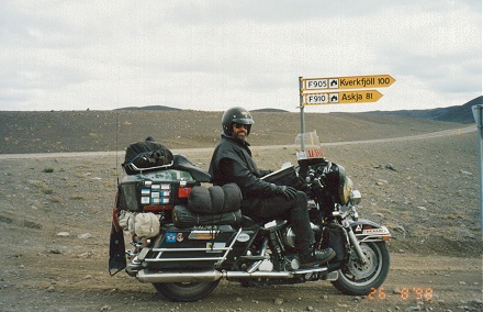 pants we managed to get through (some 30 cm deep) without
incident. The scenery along this route is stunning with mountains of volcanic
debris, snow, desert scree slopes with mosses and grasses growing in more
protected areas. The two tyre marked track winds it's way between these magnificent
formations.
pants we managed to get through (some 30 cm deep) without
incident. The scenery along this route is stunning with mountains of volcanic
debris, snow, desert scree slopes with mosses and grasses growing in more
protected areas. The two tyre marked track winds it's way between these magnificent
formations.
16/8/98 A cold 6 degrees awaited us in the morning, despite
sunshine it was cold, but after a brisk 1 1/2 hour walk through rough lava
fields and up into bubbling and steaming fumaroles and back to the campground
hot springs for a pleasant hot tub we were more than warm. The hot springs
(only 40 cm deep but extensive) bubbled from the ground and mixing with
the cold surface water you can choose your preferred temperature. It was
great this time of year but you could picture the steaming pool surrounded
by snow in winter and the relief it would be for hikers. Headed out along
the piste (dirt road) F26, this time removing the windscreen as it was gathering
dust and made the rocks and sand difficult to see in front of the motorcycle.
Through yet more lava fields and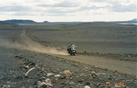 into Reykjavik, Iceland's capital.
17/8/98 Quite a basic city of 160,000 without the architectural
beauty of other European capitals due to the lack and cost of building materials.
Villi Knudsen with his father have been filming Iceland's volcanic history
since the mid 1940's and have a two hour showing of their work and Iceland's
frequent eruptions and glacial bursts. It seems a fault line running north/south
through the country is parting allowing long fissures to open periodically
causing spectacular lava flows. But with a flow every five to ten years
you have to be extremely lucky to see one on a two week trip.
18/8/98 Heading north east to Thingvellir and the Althing,
where the Vikings leaving Norway and settling in Iceland around 900 AD set
up their form of parliament. The leaders would meet regularly at this central
point to discuss the future of their country for over the next 300 years.
On then to Geysir where all the other geysers in the world get their name.
The original geyser having stopped sprouting its boiling water and steam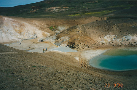 in 1930 but Strokkur, its smaller brother still manages spouts of 30 meters.
The extremes of ice and fire in this country is amazing. The third touristy
attraction in the trio is Gulfoss waterfall . Water seems to flow from the
glaciers everywhere making you wonder whether it will last but some are 600
meters thick so it should last a while. We decided to head to the north coast
via the Kjolur route, about 200 km of piste and recently bridged at the four
worst water crossings, having just three washouts to be negotiated. We found
the road to be similar to Australia's outback and provided the speed of 60
kph or more was maintained the bike glided across the corrugations with under
inflated tyres. Heading off to Kerlingarfjoll, a 12 km detour to some ice
caves (which were closed due to unusual melting and collapsing ice) we did
experience two deeper river crossings, at the last one some water was sucked
into the air filter. With the filter now above water level and the exhaust
pipes still below, full choke and throttle the motorcycle slowly fired and
we drove up out of the crossing. Camped alongside the river on the detour.
in 1930 but Strokkur, its smaller brother still manages spouts of 30 meters.
The extremes of ice and fire in this country is amazing. The third touristy
attraction in the trio is Gulfoss waterfall . Water seems to flow from the
glaciers everywhere making you wonder whether it will last but some are 600
meters thick so it should last a while. We decided to head to the north coast
via the Kjolur route, about 200 km of piste and recently bridged at the four
worst water crossings, having just three washouts to be negotiated. We found
the road to be similar to Australia's outback and provided the speed of 60
kph or more was maintained the bike glided across the corrugations with under
inflated tyres. Heading off to Kerlingarfjoll, a 12 km detour to some ice
caves (which were closed due to unusual melting and collapsing ice) we did
experience two deeper river crossings, at the last one some water was sucked
into the air filter. With the filter now above water level and the exhaust
pipes still below, full choke and throttle the motorcycle slowly fired and
we drove up out of the crossing. Camped alongside the river on the detour.
19/8/98 Headed out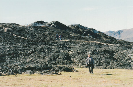 early with over 100 km of piste to go, stopping only at the Hveravellir
hot springs about half way. Here a series of over 20 hot pools, some sprouting
steam geysers, others boiling madly, blues and greens with small sintered
pools, are beautifully set in the desert. The road improved dramatically
from the power station dams and we drove through to Akureyri for the night.
Iceland is rapidly improving their roads. Allowing less adventurous tourists
into previously inaccessible areas and also restricting its off road usage.
In some ways it is taming rapidly its appeal as the only frontier of Europe.
early with over 100 km of piste to go, stopping only at the Hveravellir
hot springs about half way. Here a series of over 20 hot pools, some sprouting
steam geysers, others boiling madly, blues and greens with small sintered
pools, are beautifully set in the desert. The road improved dramatically
from the power station dams and we drove through to Akureyri for the night.
Iceland is rapidly improving their roads. Allowing less adventurous tourists
into previously inaccessible areas and also restricting its off road usage.
In some ways it is taming rapidly its appeal as the only frontier of Europe.
20/8/98 With no real rain (just drizzle) for the last
few days and a forecast of just drizzle for the next four days we decided
to attack the interior of Iceland and head towards Askja. Travelling quickly
through Myvatn (will return in two days) staying only for river information
where we were advised the need to cross about a dozen rivers, some 2/3 of
a meter deep. From the other rivers we have previously crossed, this depth
can be halved by going around the main crossing and crossing in faster but
shallower water. The round trip needing more fuel than we could carry so we
would need to detour 25 km (each way) to the rural settlement of Bru. We
set off heading down ring road 1 and off on the desert track of F905 and across
F910 to Bru.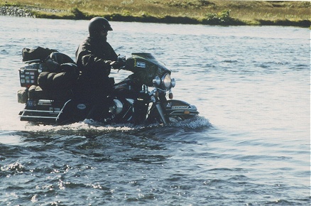 With just four shallow river crossings we arrived in Bru just as the petrol
station was closing but managed to refuel and retrace our steps back to
the F905. Here we found the first real river crossing, about 30 meters wide,
Kay had to walk the icy waters to check the depth and then I followed with
the motorcycle. Wet to the knees we camped next to the river.
With just four shallow river crossings we arrived in Bru just as the petrol
station was closing but managed to refuel and retrace our steps back to
the F905. Here we found the first real river crossing, about 30 meters wide,
Kay had to walk the icy waters to check the depth and then I followed with
the motorcycle. Wet to the knees we camped next to the river.
21/8/98 Awoke to 4 degrees and slight drizzle, with still
wet boots and pants. The drizzle continued for the next three hours while
we rode the 70 km to Askja. The first 30 km was through volcanic ash interspersed
with harder tufa. We dropped the motorcycle in the soft ash about five times
whilst developing the technique of leaning back to reduce front axle weight
and increasing speed to float across the top. This worked as long as we could
stay in the wheel tracks of other vehicles but if balance was lost slightly
a rather spectacular lock to lock slapping of the steering followed by a sudden
digging to a halt, half buried in black volcanic ash would occur. The dead
weight of the passenger I have been carrying finally became of great value
helping to lift the motorcycle, dig out the front tyre and push from the
rear. Kay had to walk some distances as restarting in some ash drifts with
two up was impossible. The final 40 km was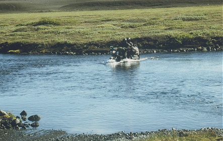 generally harder surface and in the end we were weaving
through a lava field to arrive at the Askja caldera. Its not often you get
a chance to swim in a volcanic cauldron. Lake Viti is kept at a constant
24 degrees by sulphurous fumaroles and after climbing down through thick
mist, stripping off to my birthday suit it was a tremendously relaxing end
to an arduous ride.
generally harder surface and in the end we were weaving
through a lava field to arrive at the Askja caldera. Its not often you get
a chance to swim in a volcanic cauldron. Lake Viti is kept at a constant
24 degrees by sulphurous fumaroles and after climbing down through thick
mist, stripping off to my birthday suit it was a tremendously relaxing end
to an arduous ride.
22/8/98 We had decided to stay in the hikers cabin last
night as the skies had cleared and the forecast was for 2 degrees. We awoke
to a heavy frost and clear skies, able to see the countryside for miles
that had been robbed us by yesterdays fog and drizzle. The first creek crossing
had been frozen over and despite earlier traffic there were still plates of
ice floating where we crossed. Three major river crossings today and varying
reports of their depth and width. Heading out now on the F88 past Herdubreid.
The desert scenery broken only by the oasis at the base of the mountain.
Playing it safe, Kay walked the first and smallest crossing (carrying her
boots) in the almost freezing water. The same routine at the second crossing,
a much wider one at 35 meters, and deeper (30-40 cm) with loose stones on
the downstream edge where we needed to cross. By the third crossing we were
feeling confident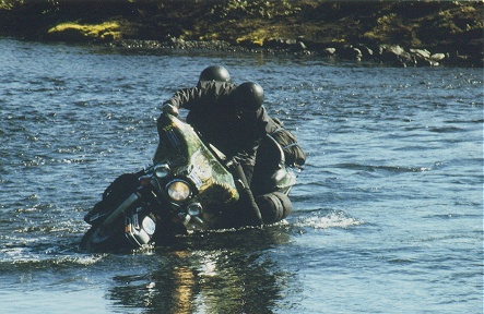 and decided to cross two up and paid the price. Loose
gravel about half way brought us off wet to the knees and the motorcycle
resting on its crash bars. After a hurried righting the motorcycle started
straight off despite the mufflers being underwater and we all emerged unscathed
though wet in the sunshine. Myvatn tonight after a hectic 250 km of piste
over the last two days.
and decided to cross two up and paid the price. Loose
gravel about half way brought us off wet to the knees and the motorcycle
resting on its crash bars. After a hurried righting the motorcycle started
straight off despite the mufflers being underwater and we all emerged unscathed
though wet in the sunshine. Myvatn tonight after a hectic 250 km of piste
over the last two days.
23/8/98 Myvatn is one of the most volcanically active
places on earth situated on the crack between two enormous tectonic plates
gradually moving apart. We walked along and across the still steaming lava
flow from the 1986 eruption where a ten kilometre crack opened up in the
earth's crust spewing out lava. Walking from the Europa plate back and forth
to the American plate. Iceland is the only place above sea level where these
two continental plates meet. It seems odd to walk from Europe to America
and back in a few minutes without getting your feet wet, tectonically speaking
that is. Overnighted again in Myvatn
24/8/98 Myvatn is also famous for its lake, formed just
2300 years ago this shallow lake is the breeding grounds for thousands of
migratory birds feeding on midge fly and their larva. These midge hatch from
May to August and although some bite most don't, and just swarm around you
everywhere you move outside. They are so thick they penetrate your ears, eyes
and nose rapidly driving you to frustration. We were at the tail end of the
season when it was said to be a light dose. The locals walk around with net
covered heads to avoid the insects.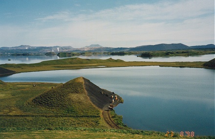
25/8/98 Moving again to Husavik famed for whale watching.
After a visit to the whale museum and a couple of videos pointing out both
sides of the harvesting of whales we headed out to sea. Just two whales,
humpbacks, seen breaching from about 1 km away and then at the surface close
up for about 30 minutes including a number of deep dives with flukes displayed.
Quite a spectacular sight. Normally Minke whales are also sighted but I can't
help pondering the incongruity of charging tourists to see whales and trying
to keep them tame for that industry while at the same time allowing harvesting
for meat of the same species in another area of the ocean nearby.
26/8/98 Camped last night at Jokulsargljufur National
park and this morning headed out to the unique basalt columnar formations
at Hljodaklettar (Iceland has such unpronounceable names). These crystal
like columns are so unusual with their honeycomb ends. Headed further south
down a deteriorating road past Dettifoss waterfall and the last 20 km before
ring road 1 was a designated jeep track winding through sandy cuttings and
rocky ridges. Overnighted at Egilsstadir.
27/8/98 Regrettably leaving Iceland at noon, two enjoyable
weeks and managing to avoid most of the rain with eight full days of sunshine,
somehow avoided the endless strong winds other motorcyclists encountered
and even managed most river crossings without incident due to the lateness
of our summer visit. (Glacial and snow melt in June and July cause high rivers
but cooler weather in August slows melting). A longer stay here would definitely
be warranted particularly on an off road motorcycle but we managed a good
look in the two weeks of some of the more remote areas. The fully loaded Smyril-Line
boat sailed with us aboard..
Move with us to Faroe Islands
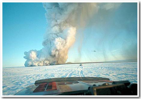 Received this email from Njall on the 19/12/98 regarding
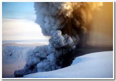
the current sub glacial volcanic action on Iceland.
Received this email from Njall on the 19/12/98 regarding
the current sub glacial volcanic action on Iceland.
Photos also with the compliments of Njall
Hi all.
Greetings from the adventure island!
For those who don't know it already, we're having an eruption
in the glacier Vatnajokull. The volcano activity is quite big as you
can see from the pictures. The smoke can be seen from Reykjavik, the
capital,
which is on the other side of the country. There is the
possibility of floods like we had two years ago. Let me know if you
want to receive more pictures and updates.
Regards,
Njall Gunnlaugsson
Managing Director
Biking Viking Motorcycle Tours