Dreaming of a motorcycle trip to distant climes? This section will help you to plan your trip, whether it's to the next state, country or all the way around the world! Start here!
The Achievable Dream 5-part series - the definitive video guide for planning your motorcycle adventure. Get Ready! covers planning, paperwork, medical and many other topics! "Inspirational and Awesome!" See the trailer here!
You could just get on a plane with your credit card and passport and buy or rent everything you need when you get there. That includes the bike, riding gear, etc. etc.
Gear Up! is a 2-DVD set, 6 hours! Which bike is right for me? How do I prepare the bike? What stuff do I need - riding gear, clothing, camping gear, first aid kit, tires, maps and GPS? What don't I need? How do I pack it all in? Lots of opinions from over 150 travellers! "will save you a fortune!"
See the trailer here!
So you've done it - got inspired, planned your trip, packed your stuff and you're on the road! This section is about staying healthy, happy and secure on your motorcycle adventure. And crossing borders, war zones or oceans!
Tire Changing!
Grant demystifies the black art of Tire Changing and Repair to help you STAY on the road! "Very informative and practical." See the trailer here!
With an HU blog, you'll get a lot more readers than in some obscure corner of the web, it's all set to go, no setup required, and it's free! Start your Travel Story Blog right now!
800+ HU Communities in over 115 countries! People who want to meet travellers - yes that's YOU - and can provide local assistance, and may be your new best friends!
Make a Difference Tips on fundraising or donating time and energy to a cause.
After the big trip - Was the trip the best - or worst - thing you ever did?
Resources and Links
Horizons Unlimited Presents!
Ladies on the Loose! For the first time ever, a motorcycle travel DVD made for women, by women! These intrepid women share their tips to help you plan your own motorcycle adventure. They also answer the women-only questions, and entertain you with amazing tales from the road! Presented by Lois Pryce, veteran solo traveller through South America and Africa and author of 'Lois on the Loose', and 'Red Tape and White Knuckles.'
"It has me all fired up to go out on my own adventure!" See the trailer here!
Meet people who don't think you're crazy for wanting to ride your bike to South America or across Asia! They will encourage you, share their experiences and advice on how to do it!
We're not a big multi-national company, just two people who love motorcycle travel and have grown a hobby into a full time job and a labour of love.
When you decide to become a Member, it helps directly support the site. You get additional privileges on the HUBB, access to the Members Private Store, and more. Of course, you get our sincere thanks, good karma and knowing you're helping to keep the motorcycle travel dream alive. :-)
All contributions are greatly appreciated and acknowledged.
T-shirts, Calendars, Stickers
T-shirts Cotton or synth sweat-wicking t-shirts with the cool Horizons Unlimited graphic on the front and a snappy slogan (changing every year) on the back.
World Map Sticker for PanniersShow your route on your panniers. Great conversation starter when you meet people on the road!
Travel BooksMotorcycle and travel books to inspire and inform you!
Videos - Watch and Learn!
Horizons Unlimited presents!
Achievable Dream The definitive guide to planning your motorcycle adventure! This insanely ambitious 2-year project has produced an informative and entertaining 5-part, 18 hour video series. "The ultimate round the world rider's how-to!" MCN UK.
"The series is 'free' because the tips and advice will save much more than you spend on buying the DVD's."
Road Heroes"Inspiring and hilarious!" (only on DVD)
Advertisers- Horizons Unlimited is well-established as the first source of reliable, unbiased information on all aspects of adventure motorcycle travel.
We reach a dedicated, worldwide group of real travellers, and are the only website focusing exclusively on long distance motorcycle travellers.
If you sell motorcycles or motorcycle accessories, riding gear, camping equipment and clothing, transport motorcycles, organize motorcycle tours, or have motorcycles to rent, you should be advertising with us!
Hi all, am currently in morocco taking a couple of friends to show them around this beautiful country. We are traveling with rented car, not 4x4 and u would like to know if someone has latest updates of road conditions of the following:
Tata-tafraoute through igherm
Zagora - foum zguid (n12)
Taroudant - marrakesh through tizin test
Rissani - nkob (n12)
I know there has been a lot of posts regarding these routes but just wanted to make a check again. Needless to say, we want to drive on sealed roads only
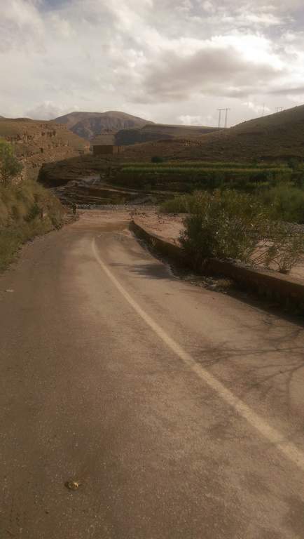
To confirm what Peter was saying above, MS5 is sealed all the way from Zagora to Foum. Zguid, drove it today in a camper van and it was in very good condition. That makes the trip between the two towns very quick if you're heading up or down The Desert Highway N12
May be a tad late to help, but will reply in case it's of use to others. We're travelling on a trike with a small trailer, so sticking mostly to tarmac with the odd bits of gravel road and piste.
Zagora - foum zguid (n12) - we took a different route from Foum Zguid - N'kob: R111 then right onto R108 to Agdz. About 35km from Alougoum north were gravel but being worked on (early April). The rest is all clear other than the odd bridge that's still out or gravelled up, but there were always easily navigable detours.
N'kob - Rissani: all clear except for the odd bits as above. The road through Rissani was one of the worst we've encountered!
As an aside, main bridge through Sidi Ifni still down but a diversion takes you round and out to Guelmim or south. Guelmim road all good, with the same gravelly bridges and odd diversions. Lots of bits of broken roads to see en route. Same true of the Assa-Foum-el-Hassan roads, then the N12 all the way through to Foum Zguid.
Anyone any idea about the condition of the roads from Zeid - Imichil - Tinerhir? We're looking at taking the road from Zeid via Boumia, Agoudim and Anefgou to Imichil, then south through Todrha.
The only info I've been able to find is going back to last November when there were chunks of road out at a few places on this route (Agoudim to Anefgou being one, along with half of the rest of the country!), but hoping that they're clear by now. We're on a trike with a small trailer - fun, but not much in the way of off-road capabilities!
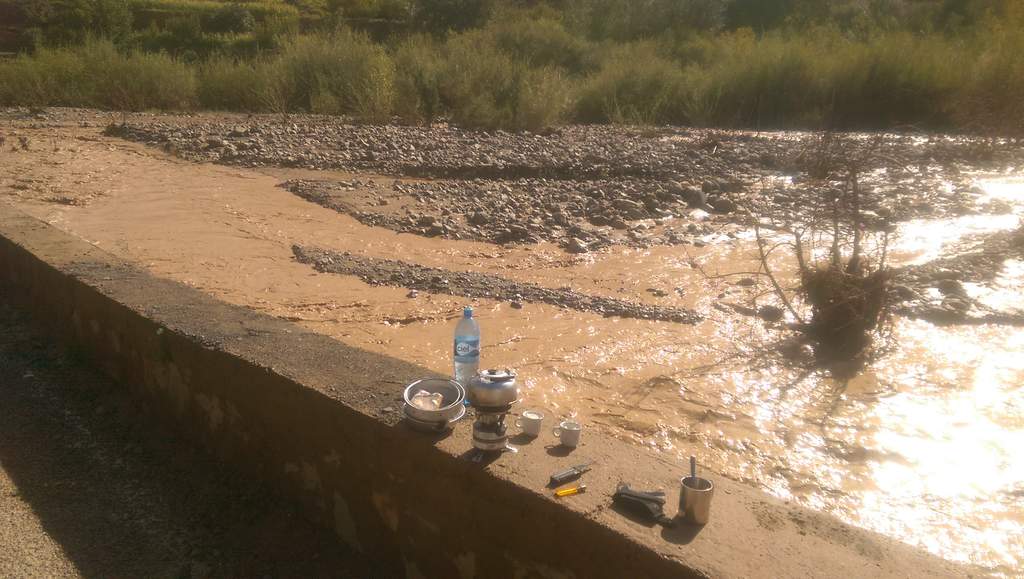
Hi, I done the section from Imilchil to Todra about a week ago, two up on a Super Tenere with a load of luggage. The condition of the road is OK but not great, there are sections where the tarmac has been eroded but nothing to worry about. The only potential problem you could face is the water levels on the numerous river crossings, we only had to deal with about 6-8 inches of water but the issue for me was the loose shingle on the river beds which made my front wheel dance all over the place, but I guess your trike will be fine.
In 2 weeks of riding in Morocco, that route was my favourite, it really is a fantastic ride!
The journey from near Midelt to Imilchil turned into our most challenging day ever! There are lots of washed out bits of the road, but where it got really interesting was a few kilometers after Tounfit, not long after the piste from the Cirque de Jaffar joined our "road". I think this is part of MH1. We came into a river valley where a lot of the road had been washed away, but were going well until we ran out of road/track completely and had to go through the river bed. About 1km in an an hour, and 3 very hairy river crossings later things got better, but we did spend some time in there debating whether we'd be able to go on or have to turn back - the challenge is not knowing what it's like further on. River must've been over 40cm deep in places as the water went over the top of Tony's bike boots, with some even deeper potholes to watch out for. The trike was OK, but the trailer has small wheels and nothing like as much ground clearance - we think it may have been floating at one point.
The upside was absolutely stunning scenery and some entertaining encounters with locals on horses and donkeys. At one point we had a couple of lovely Berber ladies on horses laughing away at the sight of us emptying water out of our boots and wringing socks out. We did only meet people on foot or horseback for a fair stretch, which should have given us some clues in hindsight! Wet feet at 2,600m was not ideal...
4WD would have no probs getting through. Decent off-road bikes would be fine but fun. Road bikes or cars would most probably not make it. We always travel a lot slower on the trike than on bikes, but even so it took us about 7 hours from start to finish. That did include stopping in Boumia for fuel, water, and a treat of our first ice creams since leaving the coast for the desert a month ago though!
We later discovered that we had taken the ancient road, which is not maintained. Locals in vehicles use an alternative route which is more navigable, but I'm not sure where that is - apparently we should have taken a different fork in the road at some point.
This is the route we took and where the road first ran out:
In the last couple of days we have completed MS5,7,&6, in that order, ( in a defender) all are clear and open. End of ms7 at m'hamid some deep loose sand, and again crossing the river bed just before ramil on ms6. Just a little note for those that are interested, whilst having a shock absorber bush sorted in merzouga, over heard conversation between garage owner and couple of local dirt bike riders that there is an apparent shortage of petrol locally today. Later in Erfoud we had no problems getting diesel, and saw no signs to suggest any problems with petrol here.
about 5kms along this piste after the first large oued a very deep ditch has been dug (may be filled in now) but a crossing has been made about 300m to North West of the old piste.
The Morrocco Overland book takes you on a fairly worn piste, unfortunatly I straayed a little too far to the West and ended in a Sandy Oued that I couldn't get of for quite some time. Would be fine in a 4x4 but not a laiden motorcycle.
There are a few sandy oued crossings but none that last any more than 100 metres.
Would suggest following the presecribed route and not veering too far!
Also, The 50 km road over this corner of the Rekkam plateau heading south from Missour is most definately a piste and now errs to a considerable degree to the east of the OSM shown route after about 5 km. I would stick with the new route as the piste is nice and easy and has been well travelled, therefore easy to navigate. after about 15-20km it rejoins the OSM.
It si quite a nice piste, not massively interesting appart from the odd camel and nomad's camp but it is great to see the mountains in the far distance come into view and as you get to them you get back on the tarmac. Would be a good first piste, It was for me!
I'm new to HUBB and this is actually my first contribution. I used the platform a lot for travel preparations so I thought I might as well share some experiences. Hope it helps.
I'm currently on Cris Scott's MH1 in Imilchil. I did the Cirque du Jaffar with my Honda XRV650 and luggage yesterday and overall found the Piste to be in good condition. Nevertheless, for those doing it the first time, it is in places fairly technical and can be dangerous. When I went the Cirque was dry, which I guess is essential - I wouldn't recommend going there in bad weather as there are some deep drops and in places the track gets quite narrow.
The big rocks that have previously been reported must've been moved - at least I didn't see them. Definitely no obstruction at all. The gradient I didn't find too dramatic - I didn't have the impression it got to up to 20° or even more. But then I was on a bike and thinks might seem a bit easier then. Most importantly though: The hairpins and narrow bends are not due to any strong gradients.
I approached the Cirque from the SW (Midelt) and found the descent into the Cirque a bit more dangerous than the following sections. The riverbeds are the main obstacle for bikers - keep some momentum and try to find a relatively straight line and you'll be OK though.
Also watch out for barbed wire - as reported previously - and for dogs. They really didn't seem to be cool in the area. Got chased by dogs twice.
As a general comment on Cris Scott's grading of the route, I don't think one can negotiate the Cirque with anything less than a 4X4, but I've seen worse Pistes as well. I found Tim Cullis' rating as a red Piste most accurate - so one can tackle it alone on a fully loaded bike, but it gets technical at bits. Again, much depends on the weather. But also, if one is offroading in Morocco, one should probably be aware of the fact that this is fairly dangerous. So if you wanna have a nice and relaxed time with loved ones you might consider either getting a driver or staying on tarmac.
Another practical advise: At the moment (as of yesterday) there seems to be a shortage of unleaded petrol in the Midelt area. I had to ride back on the N13 for about 30kms till I found some.
There have been some lightening storms in the Dades area today. Along the Gorge du Dades (I think) some places are only passable on 4x4's or Enduro bikes. More precisely, from the point were the Piste ends at the first river crossing/ bridge there were a few miles of heavy mud slides and one tricky river crossing (the first one - briefly impassable). As more rain seems likely the situation might stay like this. So if you wanna go there, expect some waiting times or an overnight stay. Otherwise take the route via Tinghir. Getting to the Cascades is no problem.
Also the piste itself I find quite dangerous in a bid of bad weather. Although not too technical, the drops are quite impressive and mud easily adds some more risk to it.
I rode along ME6 yesterday from Bouarfa to Figuig. The piste is generally in good contion however there are two washed out parts past the halfway point, nearer Figuig (don't know how long they've been there, just thought I'd mention it). There are stones layed out to warn drivers and there are ways around the washed out sections.
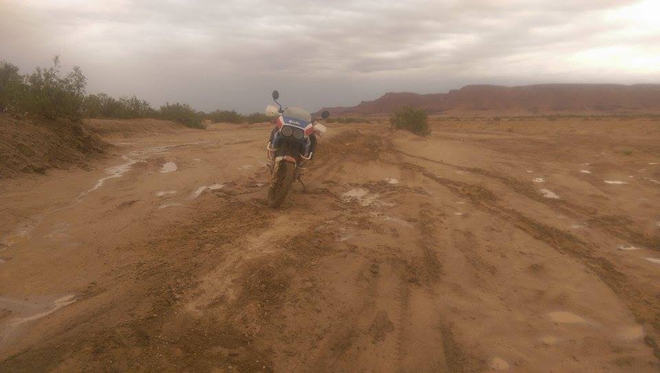
Rode through the Sahara pistes now. That is MS6 and MS7 (Merzouga - Tagounite - Foum Ziguid). The pistes (apart from the dry lakes) are generally technically quite demanding. There can be rain related trouble (although desert; mud/ quicksand). The sand is very soft, so keep your bikes light, and at other parts the terrain gets incredibly rocky. Adding to this there is the navigational risk and remoteness that can easily be underestimated by inexperienced desert riders. So don't go alone! There is no mobile signal, so help can be days away! I hired a guide and a 4x4, which over here isn't increadibly excessive. Took us 3 days, meaning there was some wild camping involved. Its well worth it! Increadible scenery!
Road conditions:
MS6: Owing to some rain Oued Rheris is a bit of a mud party. By mud I mean some very soapy mud... so quite a bit of work for a few miles. The detour further south doesn't work as you'll be stopped by the military (too close to the Algerian border). At Tafaroute there is a river crossing that was not passable. Just turn right in front of the crossing and through the palmerie for about 1km till the water level is flat enough. Was a piece of cake then. The last bit towards Tagounite was not passable due to the river crossings. So we detoured via Zagora. Quite scenic piste though.
MS7: The most tricky bit is right at the beginning shortly after Mhamid (did the southern piste through Erg Chegaga). The sand of the Erg was extremely powdery and negotiating the dunes on heavy bikes will be quite a challenge. Along the dunes there is some powdery sand that is almost indistinguishable from the rocky ground. Watch out for that! It's good for some nasty surprises. The following rock desert is fairly easy for bikes apart from one dried out river bed (you'll recognise it when you're there): Don't speed through. Tried that, almost threw me off. Lac Iriki is dry and good fun. Good to camp in the dunes east of Lac Ikiri!
Oued Rheris:
Video I made (unfortunately not of the first day):
Must be MS8. Can you provide more information why it is closed - political reason or weather etc? Also do you know if the routes between Foum Zguid and Taconite (MS7) are still open (Soutt East from Foum Zguid)?
Are you currently in the region? if yes any update on other routes?
Have YOU ever wondered who has ridden around the world? We did too - and now here's thelist of Circumnavigators!
Check it out now, and add your information if we didn't find you.
Check the RAW segments; Grant, your HU host is on every month!
Episodes below to listen to while you, err, pretend to do something or other...
2020 Edition of Chris Scott's Adventure Motorcycling Handbook.
"Ultimate global guide for red-blooded bikers planning overseas exploration. Covers choice & preparation of best bike, shipping overseas, baggage design, riding techniques, travel health, visas, documentation, safety and useful addresses." Recommended. (Grant)
Led by special operations veterans, Stanford Medicine affiliated physicians, paramedics and other travel experts, Ripcord is perfect for adventure seekers, climbers, skiers, sports enthusiasts, hunters, international travelers, humanitarian efforts, expeditions and more.
Ripcord Rescue Travel Insurance™ combines into a single integrated program the best evacuation and rescue with the premier travel insurance coverages designed for adventurers and travel is covered on motorcycles of all sizes.
(ONLY US RESIDENTS and currently has a limit of 60 days.)
"This site is the BIBLE for international bike travelers." Greg, Australia
"Thank you! The web site, The travels, The insight, The inspiration, Everything, just thanks." Colin, UK
"My friend and I are planning a trip from Singapore to England... We found (the HU) site invaluable as an aid to planning and have based a lot of our purchases (bikes, riding gear, etc.) on what we have learned from this site." Phil, Australia
"I for one always had an adventurous spirit, but you and Susan lit the fire for my trip and I'll be forever grateful for what you two do to inspire others to just do it." Brent, USA
"Your website is a mecca of valuable information and the (video) series is informative, entertaining, and inspiring!" Jennifer, Canada
"Your worldwide organisation and events are the Go To places to for all serious touring and aspiring touring bikers." Trevor, South Africa
"This is the answer to all my questions." Haydn, Australia
"Keep going the excellent work you are doing for Horizons Unlimited - I love it!" Thomas, Germany
Every book a diary
Every chapter a day
Every day a journey
Refreshingly honest and compelling tales: the hights and lows of a life on the road. Solo, unsupported, budget journeys of discovery.
Authentic, engaging and evocative travel memoirs, overland, around the world and through life.
All 8 books availablefrom the author or as eBooks and audio books
Back Road Map Books and Backroad GPS Maps for all of Canada - a must have!
Horizons Unlimited is not a big multi-national company, just two people who love motorcycle travel and have grown what started as a hobby in 1997 into a full time job (usually 8-10 hours per day and 7 days a week) and a labour of love. To keep it going and a roof over our heads, we run events all over the world with the help of volunteers; we sell inspirational and informative DVDs; we have a few selected advertisers; and we make a small amount from memberships.
You don't have to be a Member to come to an HU meeting, access the website, or ask questions on the HUBB. What you get for your membership contribution is our sincere gratitude, good karma and knowing that you're helping to keep the motorcycle travel dream alive. Contributing Members and Gold Members do get additional features on the HUBB. Here's a list of all the Member benefits on the HUBB.


 125Likes


 Linear Mode


