 71Likes 71Likes
 |
|

20 Nov 2014
|
|
Registered Users
Veteran HUBBer
|
|
Join Date: Aug 2005
Location: Calgary AB
Posts: 1,028
|
|
|
Let's try and define this app.
I'm pretty happy with what I've been using thus far. But I'm now using it less on the bike, and more in the backcountry. Will be using the phone as a backcountry ski touring nav device in the Canadian Rockies and Columbia Mountains this winter. See how that'll go. The guide/ instructor at the Avi course said they can't handle the cold. But that's circumstantial as well.
|
22 Nov 2014
|
|
Registered Users
Veteran HUBBer
|
|
Join Date: Mar 2007
Location: UK
Posts: 4,343
|
|
Quote:
Originally Posted by tmotten

Let's try and define this app.
I'm pretty happy with what I've been using thus far. But I'm now using it less on the bike, and more in the backcountry. Will be using the phone as a backcountry ski touring nav device in the Canadian Rockies and Columbia Mountains this winter. See how that'll go. The guide/ instructor at the Avi course said they can't handle the cold. But that's circumstantial as well.
|
I'm 99% sure that you mean to define Backcountry navigator, but which app will you use for vehicle navigation if the former is becoming dedicated to navigation on foot/skis and the like?
There again, with the weather as it is in the north of America you probably don't need anything other than skis at present!
Currently, I continue an interest in "where the maps come from in the first place".
I expected this to be fairly straight forward but it isn't; there are regional considerations (basically why produce and market maps for a small, non-populated area when there are big places to hand) for instance. And then there is the business aspect, whereby just because there is an app out there doesn't mean that they own and supply the actual map data - this relates to the growing popularity of the open source OSM, but it applies to others also.
Within the business "model" there is the market for automobile Sat Nav which is massive compared with some others such as motorcycles, although I could envisage a day when all new bikes come fitted with a built in Sat Nav system just as has occurred with cars.
Here is but one example of the way things are, but it is by no means up to date or complete as the discussion page associated with it shows.
Comparison of web map services - Wikipedia, the free encyclopedia
Talk:Comparison of web map services - Wikipedia, the free encyclopedia
And, that table hardly starts to consider the application of digital mapping to mobile devices with a built in bias therein toward OSMAnd at present (maybe the mobile contribution was made by someone associated with OSMAnd, who knows?!!)
__________________
Dave
|
24 Nov 2014
|
|
Registered Users
Veteran HUBBer
|
|
Join Date: Mar 2007
Location: UK
Posts: 4,343
|
|
Quote:
Originally Posted by Walkabout
|
The link above got me looking in a bit more detail at the sources of maps used by those mapping services listed in the link; those sources are listed as --
Map Data Providers MAPIT, TeleAtlas, DigitalGlobe, MDA Federal, user contributions NAVTEQ, TeleAtlas, i-cubed, Public domain NAVTEQ, Intermap, Pictometry International, NASA Navteq, OpenStreetMap user contributions User Contributions Navteq TomTom, and others
That led me to this business https://www.whereismaps.com/device/p...on-device.html who appear to be the "others" alongside Tom Tom for the Antipodes (one of them anyway).
Just goes to show how the acquisition of data for mapping is still regionalised although I suspect that there will be considerable ongoing rationalisation (in business terms) of such companies as businesses attempt to dominate in this market.
__________________
Dave
|
24 Nov 2014
|
|
Registered Users
Veteran HUBBer
|
|
Join Date: Mar 2007
Location: UK
Posts: 4,343
|
|
""For software, I have just re-read the whole thread to remind myself of the themes here .......................................
the softwares identified in here are:-
Locus
OSMAnd
Navfree
MapDroyd
Backcountry Navigator
Androzic (Oziexplorer?)
Sourceforge
Soviet Military Maps Free
Mapquest
Google Maps
Skobbler
Viewranger
Sygic
Navigon (now owned by Garmin)
Tom Tom on Android
Ovimaps (therein lies a story)
MapsWithMe (now Maps.me)
MotionX
Navit
iOverlander (this slipped in as an IPhone OS?)
Avenza
PathAway""
That list from earlier and the increasing use and popularity of OSM led me to consider open cycle map:-
OpenCycleMap.org - the OpenStreetMap Cycle Map
This may be biased toward the UK; I don't know because I haven't looked at it in much detail, but it definitely acknowledges OSM as its' base mapping for its' own purposes.
Having just ditched Maps.me from my phone for reasons stated earlier (I think - can't quite remember if that was in this thread or somewhere else!!) I am now trying out viewranger from the list above.
First impressions are that this is a very comprehensive android navigation and mapping app.
For instance, it seems to do tracks and routes while it provides access to the following maps as routine while connected online and it can save maps for use offline:-
OSM, courtesy of Mapquest
OSM, standalone
Opencyclemap
Bing Aerial Imagery (so, a competitor to google maps imagery also on android, naturally)
Skiing map
Transport map
OR your own previously saved maps
__________________
Dave
|
24 Nov 2014
|
|
Registered Users
Veteran HUBBer
|
|
Join Date: Aug 2005
Location: Calgary AB
Posts: 1,028
|
|
Quote:
Originally Posted by Walkabout
I'm 99% sure that you mean to define Backcountry navigator, but which app will you use for vehicle navigation if the former is becoming dedicated to navigation on foot/skis and the like?
There again, with the weather as it is in the north of America you probably don't need anything other than skis at present!
|
Actually, Calgary didn't get a whole lot of snow, but the heavens seem to be opening this week.
I guess I'm coming from it from a different angle. Luckily the platform allows for the large differences in use which is why I'm loving it so much. I don't see the need for something to tell me I need to make a right turn at a T junction. If I'm not sure in the direction I'm heading, which is usually in the middle of the day with the sun dead above you, Backcountry Navigator will be enough. When I get to cities there are plenty of apps that could be used with openstreetmap.
I kind of draw a line in category between the 2. 1 being a topo mapping tool, the other a city mapping tool. The use for it (car, cycle, bike, ski's or walking) is irrelevant. So long at it allows off-line, the zoom is smooth and uncluttered and the positioning is accurate (hence the interest in BN) I'm happy a Larry.
|
25 Nov 2014
|
|
Registered Users
Veteran HUBBer
|
|
Join Date: Mar 2007
Location: UK
Posts: 4,343
|
|
Quote:
Originally Posted by tmotten
I guess I'm coming from it from a different angle. Luckily the platform allows for the large differences in use which is why I'm loving it so much
|
I guess you will stick with backcountry navigator (BN) in that case no matter what means of transport/movement is in use.
I surmise that you have found your own "killer app" whereas I am still experimenting with a few - however I haven't yet tried out BN.
Quote:
Originally Posted by tmotten
I don't see the need for something to tell me I need to make a right turn at a T junction. If I'm not sure in the direction I'm heading, which is usually in the middle of the day with the sun dead above you, Backcountry Navigator will be enough. When I get to cities there are plenty of apps that could be used with openstreetmap.
I kind of draw a line in category between the 2. 1 being a topo mapping tool, the other a city mapping tool. The use for it (car, cycle, bike, ski's or walking) is irrelevant. So long at it allows off-line, the zoom is smooth and uncluttered and the positioning is accurate (hence the interest in BN) I'm happy a Larry.
|
We are broadly thinking the same way: I use turn-by-turn navigation when it is helpful such as close into a final destination in a large, unknown-to-me conurbation. The rest of the time I am also a "happy as Larry" free-runner.
Quote:
Originally Posted by tmotten
Actually, Calgary didn't get a whole lot of snow, but the heavens seem to be opening this week.
|
Nice! Better than the rain.
__________________
Dave
|
13 Dec 2014
|
|
Registered Users
Veteran HUBBer
|
|
Join Date: Mar 2007
Location: UK
Posts: 4,343
|
|
|
Copilot for any pilot
Quote:
Originally Posted by tmotten
Good post but I disagree with your statement that a phone can't achieve the same results in urban areas as a dedicated GPS.
|
I've just fallen upon this smartphone app that seems to do just about everything in the urban environment (for those who like to have their hand held ever so tightly while navigating).
CoPilot - Your Best way to Navigate
It's not one I can remember hearing of previously (perhaps because their webpage has a definite slant towards the north american continent) and I certainly haven't investigated it at all - maybe some one has tried it??
__________________
Dave
|
14 Dec 2014
|
|
Registered Users
Veteran HUBBer
|
|
Join Date: Mar 2007
Location: UK
Posts: 4,343
|
|
|
One for the iPhone enthusiasts
I came on this while looking for information about alternative sources of digital mapping.
Route Planning on the iPhone | Adventure GPX
Although it is specifically about iPhones it also relates to the wider topic of said maps and also the software available nowdays for route planning (something which has scarcely been mentioned herein previously).
__________________
Dave
|
15 Dec 2014
|
|
Registered Users
Veteran HUBBer
|
|
Join Date: Mar 2007
Location: UK
Posts: 4,343
|
|
|
Copilot update
Quote:
Originally Posted by Walkabout
I've just fallen upon this smartphone app that seems to do just about everything in the urban environment (for those who like to have their hand held ever so tightly while navigating).
CoPilot - Your Best way to Navigate
It's not one I can remember hearing of previously (perhaps because their webpage has a definite slant towards the north american continent) and I certainly haven't investigated it at all - maybe some one has tried it?? |
Reading in other places I glean that this particular app is very orientated to the market in north america; so much so that to purchase maps for other parts of the world is a relatively expensive transaction compared with the competitors.
On that basis I would expect it to remain "pinned" to the americas, certainly for anyone who does some basic research.
Meanwhile I have remembered this thread of a while ago:-
http://www.horizonsunlimited.com/hub...software-72464
(I took nearly a year off from this type of interest to get on with my other life and I kind of thought this information was part of this thread).
__________________
Dave
Last edited by Walkabout; 17 Dec 2014 at 20:58.
|
16 Dec 2014
|
|
Gold Member
Veteran HUBBer
|
|
Join Date: Jan 2002
Location: Toronto, Canada
Posts: 2,134
|
|
Well, I did a 7,000 mile trip during November, from Toronto to Alabama to California then back again, and I tried out both navigation methods.
I used the Sygic GPS application running on an Apple 4S for the first 2,000 miles of the trip. It worked, in the sense that it provided me with navigational guidance. It had a few drawbacks:
1) The iPhone is not waterproof, I had to put it in a Baggie whenever it was wet out or was raining.
2) The buttons (soft-keys, actually) on the iPhone were far too tiny to operate when riding the bike and wearing leather gloves (temperatures were near freezing for much of this trip). In fact, the darn buttons were so tiny it was almost impossible to operate them while riding even if I was not wearing gloves. This meant that making any adjustments to the route, display, etc. required a stop at the side of the road.
3) Display could be difficult to see in bright sunlight.
On the other hand, the 'navigation via smartphone' had a few advantages:
4) Less stuff to carry, since I would have taken a phone along with me on this trip anyway.
5) Relatively cheap ($100) application, map subscription, and application add-ons. I already owned the phone, so no additional disbursement there.
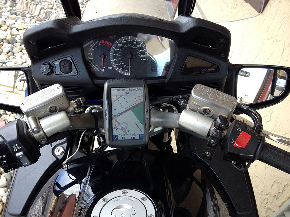
After 2,500 miles, I bought a Garmin Zumo 590 and installed it on the motorcycle. It presented the following advantages:
1) Waterproof, huge buttons (soft-keys), easy to operate while riding wearing leather gloves. Very easy to read in bright sunlight - the brighter the sunlight, the easier it was to read (see picture below, which was taken in bright sunlight).
2) Much larger (dimensionally) display, which made it a lot easier to quickly interpret the information with one fast glance. I think the iPhone actually has a higher resolution display (more pixels), but too much information was crammed into the Sygic display, hence it was not easy to interpret quickly.
3) Much easier quick look-up, while riding, of places I wanted to visit ahead of me on my route, such as restaurants, hotels, and gas stations.
4) Fewer button-pushes needed to switch between modes of operation (navigation, phone, music, weather forecasts).
5) It monitored my tire pressure for me, which was nice.
The Garmin had a few disadvantages:
6) It was expensive, $800.
7) Initial install of the cradle & wiring harness took some time.
------------------------------------
What I learned:
- It's quite remarkable that a $100 application running on a smartphone can suffice to provide navigation guidance from Toronto, Canada down to the Gulf Coast of the USA. It wasn't pleasant, but it did the job and got me there.
- Navigation via a smartphone is a bit like a dog walking on its hind legs: What is impressive is that the dog can do it at all, not how well the dog does it.
- If I want to use a smartphone for navigation, either in the car or on the moto, I have to stop the vehicle to make inputs to the smartphone. This is because of the very small control buttons presented.
- The purpose-built Garmin device costs 8 times as much, but is significantly easier to use and to interpret (to view). I'm happy I spent the money buying it.
So, there you have it, a review of both devices over the course of a very long winter motorcycle ride.
My take-away is that if a rider only occasionally needs to use a navigation device on a motorcycle, and already has a smartphone that has a physically large screen (5 inches diagonal or more), then the smartphone with the Sygic application could take the place of a dedicated GPS navigator.
But, if a rider plans to frequently or continually use a GPS device for navigational guidance, I think it would be best - and safest - to buy a waterproof dedicated GPS navigator, preferably one that is designed for motorcycle use.
Michael
The Zumo 590
|
17 Dec 2014
|
|
Registered Users
Veteran HUBBer
|
|
Join Date: Mar 2007
Location: UK
Posts: 4,343
|
|
Quote:
Originally Posted by PanEuropean
5) Relatively cheap ($100) application, map subscription, and application add-ons. I already owned the phone, so no additional disbursement there.
After 2,500 miles, I bought a Garmin Zumo 590 and installed it on the motorcycle. It presented the following advantages:
2) Much larger (dimensionally) display, which made it a lot easier to quickly interpret the information with one fast glance. I think the iPhone actually has a higher resolution display (more pixels), but too much information was crammed into the Sygic display, hence it was not easy to interpret quickly.
The Garmin had a few disadvantages:
6) It was expensive, $800.
------------------------------------
What I learned:
- It's quite remarkable that a $100 application running on a smartphone can suffice to provide navigation guidance from Toronto, Canada down to the Gulf Coast of the USA. It wasn't pleasant, but it did the job and got me there.
- Navigation via a smartphone is a bit like a dog walking on its hind legs: What is impressive is that the dog can do it at all, not how well the dog does it.
So, there you have it, a review of both devices over the course of a very long winter motorcycle ride.
|
That was a good road trip PanE.
I am not an iPhone enthusiast so I will not pass comment on that aspect.
However -
I wouldn't, personally, spend 100 of any currency on a smart phone app simply to trial it when there are so many free ones out there.
In fact my smart phone cost less than that in GB pounds.
And, you bought maps when OSM is out there on many apps for free.
Naturally, nor would I spend 800  tokens on a GPS!
So, we are definitely in two different economies.
I don't know anything about the sygic display but many of the competitor apps have displays that can be tweaked i.e. pre-set by the owner/user to display just about whatever is required, or display just the map. I imagine that only the most expensive GPS have that same feature.
One of them that I tried out over a year ago has a pitch, roll and yaw option that might appeal to you e.g. could be useful in a microlight.
I don't arrive at your lessons learnt therefore, primarily for the reason that you trialled just one of the vast range of apps that are on the market (and an expensive one at that!); the thinking about the pros and cons are well explored in earlier posts, including the aspect of urban Vs remote area use of navigation aids.
Incidentally, but of relevance, I would have liked to know how your trial coped with aural navigation - in the sense that I much prefer listening to a navigational aid rather than developing "screen fixation".
I look forward to reading about your future trials!
__________________
Dave
|
18 Dec 2014
|
|
Registered Users
Veteran HUBBer
|
|
Join Date: Nov 2014
Location: Netherlands
Posts: 157
|
|
|
I have a gpsmap62c from Garmin which I love but.. it runs on two penlite AA batteries. I now haul a (heavy) charger for this purpose only. Anyone with a better solution? As far as I know you can't charge the batteries while in the device. Take a gamble and hope to run into a charger somewhere ? How common are they along the road? Or what other are there?
Fortune and Glory, kid. Fortune and Glory.
|
18 Dec 2014
|
 |
Registered Users
Veteran HUBBer
|
|
Join Date: Jun 2000
Location: GOC
Posts: 3,364
|
|
Quote:
Originally Posted by Blommetje
I have a gpsmap62c from Garmin which I love but.. it runs on two penlite AA batteries. I now haul a (heavy) charger for this purpose only. Anyone with a better solution? As far as I know you can't charge the batteries while in the device. Take a gamble and hope to run into a charger somewhere ? How common are they along the road? Or what other are there?
Fortune and Glory, kid. Fortune and Glory.
|
A few months ago I was in the market to replace my Garmin 60CSx. It was starting to behave a little erratically. (Turned out it just needed a software update and to fully dry out from being fully submerged for 15 minutes)
https://www.youtube.com/watch?v=6maYFQEnokk 
The 62 looked like an option because it would have fitted in the same RAM cradle, but could only be powered via usb or AA batteries. So I went out and bought another used, but newer, 60CSx instead. Why? Because I have a dedicated (generally water repellant) power jack that runs from the 12v bike battery that fits the 60. So the AA batteries are only needed when the unit is off the bike.
Now I carry 2 units: One is a spare that carries the same mapping software and tracks/routes/waypoints/pois.
I also like my 60 because it has buttons and no touch screen.
|
18 Dec 2014
|
|
Registered Users
Veteran HUBBer
|
|
Join Date: Nov 2014
Location: Netherlands
Posts: 157
|
|
|
So I need to fix a powered wire to the dashboard and connect via USB? That way no batteries are needed and I can use it? So far it shoots into pc mode as soon as USB is inserted.. I'll try some more. Sorry about this though. I'm permanently blocked from the gps forum back home since 'lot of attacks are coming from asia' ... so I can't ask it there. Thanks though!!
Fortune and Glory, kid. Fortune and Glory.
|
18 Dec 2014
|
|
Gold Member
Veteran HUBBer
|
|
Join Date: Jan 2002
Location: Toronto, Canada
Posts: 2,134
|
|
Quote:
Originally Posted by Walkabout
I am not an iPhone enthusiast so I will not pass comment on that aspect.
|
I am not at all a cognoscenti of mobile phones - I used a Blackberry for years because that was what my company gave me. I asked them to give me an iPhone a few years ago because it could run an aviation weather app that would save me a lot of time when working. When I retired, they let me keep the phone, and I have no plans to replace it until it dies. It works, it makes phone calls, it runs a small selection of specialty apps that I find useful. That's enough for me. I'm not a heavy user of the phone, I often ignore it for days at a time.
Quote:
Originally Posted by Walkabout
I wouldn't, personally, spend 100 of any currency on a smart phone app simply to trial it when there are so many free ones out there.
|
I only chose that application (which cost about $100, with all the maps and a few select add-ons) because Seoul Joe spoke so highly about it in his many posts earlier in this same thread.
Quote:
Originally Posted by Walkabout
I don't know anything about the Sygic display but many of the competitor apps have displays that can be tweaked i.e. pre-set by the owner/user to display just about whatever is required, or display just the map. I imagine that only the most expensive GPS have that same feature.
|
But, what a software developer might term a 'feature' is not necessarily a 'benefit' to the user. I remember that 10 years ago, a user could heavily customize the screen appearance and level of data presented on the Garmin GPS units, for example, the StreetPilot III. I spend hours fooling around trying to fine-tune the device so it displayed only what I wanted, in a layout that I thought best.
Beginning about 7 years ago, with the introduction of the Nuvi series, Garmin thinned out about 90% of the user-configurable controls from the display. I remember complaining about that (I was a beta-tester for Garmin at the time) and being told by the software team to just settle down and try the new strategy out for a couple of months. Sure enough, a couple of months later, I realized that it was actually a lot simpler and faster to use the newer design... too much user customization ability can actually be a burden, rather than a benefit. Sort of like DOS 3.1 vs. Windows 7, if you know what I mean.
Since then, advances in processing power and continued software development have greatly simplified operation of the Garmin devices. When I fitted the Zumo 590, the biggest choice I had to make (and about the only choice I truly needed to make) was whether to run it in landscape or portrait mode. As for everything else, the device was designed thoughtfully enough to ensure that it gave me the information I needed when I needed it, and didn't bother me with unnecessary information when I didn't need it.
Very careful attention that the software development team paid to what was displayed when on the screen meant that I rarely needed to adjust the zoom level, or the brightness, or go 'digging' into menus to find more detailed information.
Quote:
Originally Posted by Walkabout
One of them that I tried out over a year ago has a pitch, roll and yaw option that might appeal to you e.g. could be useful in a microlight.
|
Oh God no. The worst that can happen when fooling around with consumer electronics for vehicle navigation is that you get lost. The stakes are higher in flight. For any aviation-related matters, the device needs to comply with the TSO (Technical Standards Orders) set out for aviation use, otherwise I think it is safest to simply leave it off the aircraft. The only possible exception I can see to that would be using an automotive navigator (phone or dedicated) to assist with visual navigation in extremely small recreational aircraft (ultralights or microlights). But, my background is commercial transport aircraft, I have no experience with recreational aircraft.
Quote:
Originally Posted by Walkabout
I don't arrive at your lessons learnt...
|
What I tried to do was compare the best available phone-based navigator (that evaluation having been provided by Seoul Joe) with the best available dedicated GPS navigator.
Quote:
Originally Posted by Walkabout
I would have liked to know how your trial coped with aural navigation - in the sense that I much prefer listening to a navigational aid rather than developing "screen fixation".
|
A very good question.
I was disappointed with the quality of the aural prompts provided by the Sygic smartphone application. It provided 'correct' prompts, in the sense that the directions given were appropriate, but the quality of the synthetic voice was wretched - it sounded like a cartoon character, and the speed of the voice was too fast. There was no implementation of phrasing. It was not, by any means, 'natural speech'.
On the other hand, the Zumo 590 voice prompt quality was a great (and pleasant) surprise to me. Garmin has made major improvements - full order of magnitude improvements - to the quality of the audio prompts.
Not only were the voices entirely natural and extremely easy to understand, the speech was 'natural' - phrases, pauses, and inflection almost perfectly matched natural speech. Even dialect could be selected (British English used the term 'slip roads', American English spoke of 'on and off ramps'). The aural prompts also took full advantage of the road attributes contained in the database. Hence, a series of aural prompts for a single right turn might go like this:
(2 km prior): In 2 km, turn right on Highway 10.
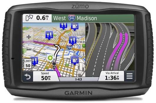
(1 km prior): Be in either of the two right lanes. (or) Be in the right lane. (At the same moment, a photo-realistic view of the available lanes would be presented, with the desired lanes clearly highlighted, as illustrated in the image below).
(400 m prior): Turn right at the Esso station.
(100 m prior): Turn right on Highway 10 now.
I like voice prompts, but for me, they serve a different and non-overlapping purpose to the map displayed on the screen. The voice prompts provide tactical guidance, meaning, they tell you what you have to do right now. The map, on the other hand, provides strategic guidance - it shows you what your overall navigational plan is, and how you are progressing towards your goal.
Lane Guidance provided with voice prompt for appropriate lane
The picture doesn't match the example I provided above, but I think you will get the general idea.
Quote:
Originally Posted by Walkabout
I look forward to reading about your future trials!
|
Thank you for that compliment, but I don't think I will be doing any more trials of navigational equipment. Now that I have figured out how the Zumo 590 works, I intend to use it to assist me in achieving my primary objective, which is pleasant, relaxed sight-seeing and touring on my motorcycle.
As for the phone application, I'll keep it on my phone. I can see it being useful in the future when I visit other countries (without the motorcycle). For example, I will be going to Sudan and Vietnam in the new year... I have no desire to bring a dedicated navigator along, and the phone app should be perfect for whatever navigation needs (pedestrian or in a taxi, for example) I might have in those countries.
Michael
Last edited by PanEuropean; 18 Dec 2014 at 17:46.
Reason: added image showing lane guidance
|
|
Currently Active Users Viewing This Thread: 1 (0 Registered Users and/or Members and 1 guests)
|
|
|
 Posting Rules
|
You may not post new threads
You may not post replies
You may not post attachments
You may not edit your posts
HTML code is Off
|
|
|
|

Check the RAW segments; Grant, your HU host is on every month!
Episodes below to listen to while you, err, pretend to do something or other...

2020 Edition of Chris Scott's Adventure Motorcycling Handbook.
"Ultimate global guide for red-blooded bikers planning overseas exploration. Covers choice & preparation of best bike, shipping overseas, baggage design, riding techniques, travel health, visas, documentation, safety and useful addresses." Recommended. (Grant)

Led by special operations veterans, Stanford Medicine affiliated physicians, paramedics and other travel experts, Ripcord is perfect for adventure seekers, climbers, skiers, sports enthusiasts, hunters, international travelers, humanitarian efforts, expeditions and more.
Ripcord Rescue Travel Insurance™ combines into a single integrated program the best evacuation and rescue with the premier travel insurance coverages designed for adventurers and travel is covered on motorcycles of all sizes.
(ONLY US RESIDENTS and currently has a limit of 60 days.)
Ripcord Evacuation Insurance is available for ALL nationalities.
What others say about HU...
"This site is the BIBLE for international bike travelers." Greg, Australia
"Thank you! The web site, The travels, The insight, The inspiration, Everything, just thanks." Colin, UK
"My friend and I are planning a trip from Singapore to England... We found (the HU) site invaluable as an aid to planning and have based a lot of our purchases (bikes, riding gear, etc.) on what we have learned from this site." Phil, Australia
"I for one always had an adventurous spirit, but you and Susan lit the fire for my trip and I'll be forever grateful for what you two do to inspire others to just do it." Brent, USA
"Your website is a mecca of valuable information and the (video) series is informative, entertaining, and inspiring!" Jennifer, Canada
"Your worldwide organisation and events are the Go To places to for all serious touring and aspiring touring bikers." Trevor, South Africa
"This is the answer to all my questions." Haydn, Australia
"Keep going the excellent work you are doing for Horizons Unlimited - I love it!" Thomas, Germany
Lots more comments here!

Every book a diary
Every chapter a day
Every day a journey
Refreshingly honest and compelling tales: the hights and lows of a life on the road. Solo, unsupported, budget journeys of discovery.
Authentic, engaging and evocative travel memoirs, overland, around the world and through life.
All 8 books available from the author or as eBooks and audio books
Back Road Map Books and Backroad GPS Maps for all of Canada - a must have!
New to Horizons Unlimited?
New to motorcycle travelling? New to the HU site? Confused? Too many options? It's really very simple - just 4 easy steps!
Horizons Unlimited was founded in 1997 by Grant and Susan Johnson following their journey around the world on a BMW R80G/S.
 Read more about Grant & Susan's story
Membership - help keep us going!
Horizons Unlimited is not a big multi-national company, just two people who love motorcycle travel and have grown what started as a hobby in 1997 into a full time job (usually 8-10 hours per day and 7 days a week) and a labour of love. To keep it going and a roof over our heads, we run events all over the world with the help of volunteers; we sell inspirational and informative DVDs; we have a few selected advertisers; and we make a small amount from memberships.
You don't have to be a Member to come to an HU meeting, access the website, or ask questions on the HUBB. What you get for your membership contribution is our sincere gratitude, good karma and knowing that you're helping to keep the motorcycle travel dream alive. Contributing Members and Gold Members do get additional features on the HUBB. Here's a list of all the Member benefits on the HUBB.
|
|
|


 Linear Mode


