 1Likes 1Likes
 |

11 Aug 2013
|
|
Registered Users
HUBB regular
|
|
Join Date: Mar 2013
Posts: 73
|
|
|
One possibility: multifocals.
I've had cataract surgery on one eye, and the other is pretty bad from a detached retina, so that's what works for me.
Sent from my A898 Duo using Tapatalk 4
|
14 Aug 2013
|
 |
Contributing Member
HUBB regular
|
|
Join Date: Jan 2012
Location: Quebec, Canada
Posts: 40
|
|
Has anyone seen or used this device?
http://www.meetearl.com/
It seems to incorporate most everything an overlander would want in a navigation device including GPS, radio, walkie-talkie and weather forecasts.
Plus it seems to run on an androide operating system.
Seems to good to be true.
|
14 Aug 2013
|
|
Registered Users
Veteran HUBBer
|
|
Join Date: Feb 2012
Posts: 834
|
|
I think we had to discuss here - how and where to travel.
When you plan to travel more abroad at sample on the silk road or crossing africa - a normal road based map would be not that helpful.
Pretty easy is a Ipad based (offline) solution:
Ipad for Road Navigation
Ipad for Offroad Navigation (Bing Satellite & Hybrid Map)

There is GPS-Device arround who can top such a setup.
Also when you had a much stronger solution with a windows based tablet - it is not easy to optain satellite Images for offline usage at sample.
With a Windows Device you have more tools for navigation, but you had to spend more time to "learn" how to do it. With the Ipad it is pretty easy.
You can also use your Ipad as USB Stick and swap Files between your devices: use your Ipad as Storage
This works with any iPad with 3G and also with any iPhone. If you travel with an iPad (normal/mini) - you can use your iphone as failover device.
We had used this setup for our transafrica - and it had worked well! We had downloaded for the whole route the bing satellite hybrid imagery from Zoomlevel 3-14. Hybrid means that it is the satellite view with also the roads layer.
Some get the cheaper non 3G iPads and use external GPS devices.. You can do that but it is not necessary. We had used the 3G Version.
Actually you can Download Google, Bing Navtec (Nokia Ovi) and many more sources...
Here you find too a short walkthrough at HuBB: http://www.horizonsunlimited.com/hub...atellite-72663
Surfy
Last edited by Surfy; 16 Oct 2013 at 18:52.
|
23 Aug 2013
|
|
Registered Users
Veteran HUBBer
|
|
Join Date: Mar 2007
Location: UK
Posts: 4,343
|
|
Quote:
Originally Posted by tigershel

Also check OsmAnd, seems to be one of the default app choices for OSM maps and is open source.
The free version allows you to download up to 10 regions, and it's quite user friendly.
Where I am now, the offline OSM vector map is a lot more accurate than Google maps, the only better map I have found is a country specific collaborative Garmin-compatible map.
I reckon the tablet could work fine in a 4-wheeler, I still prefer a GPS like the Garmin Montana (or the new Android one that uses the Montana hardware) for durability and ability to be used on the bike, hiking, and boating.
Another question: why a tablet? There are relatively cheap and powerful Android phones available with screens from 4.3" to 6.5" which are possibly more robust and flexible. There are probably more mounting options for the more standard sizes.
It could also provide a backup to your dedicated phone, assuming you take one. Most of the better Android chinaphones allow for 2 or more sim cards to be installed, quite useful if you are traveling in are where coverage varies by network, or where you may want one card with a data plan, and another with a call/SMS option.
You can also get apps that will allow the phone to serve as the GPS to a Bluetooth laptop or tablet.
Having said that, some of the phones I've tried have poor GPS reception, taking a long time to get a satellite lock, and also battling in mountains, forests and built up urban areas.
In that case I often use a bluetooth GPS tracker dongle/mouse instead of the onboard GPS. It seems as powerful as the dedicated GPS systems, and gets 25 to 40 hours on a charge.
It also works with my Android tablets (2.3 and 4.0) and my Windows laptop.
Another advantage with the bluetooth tracker is that it is small and easier to mount where it can pick up a good signal, letting you position the phone / tablet for optimal viewing and safety. It also helps keep the phone / tablet out of the sun, high temperature is a killer for many devices and batteries.
The tracker I am using is an older Qstarz BT1000Q , and I use Bluetooth GPS Tracker from Argotronic (IIRC) to connect it to my Android phone and tablet. That app seems the most reliable of the 3 or 4 I have tried.
Sent from my A898 Duo using Tapatalk 2
|
Personally, I keep the mobile phone strictly for making telephone calls and the occasional text - it's old fashioned, but I can't see me changing that for a long time, if ever.
My favourite nav device remains paper maps - again old fashioned - and I tend to prefer one device for each purpose, so I do have an old Garmin for navigation but I have become disenchanted with it I suppose; I do fully appreciate the value of waypoints and the associated accurate position fixes, but a lot of the time I don't need them - when I do, the Garmin is switched on, otherwise it tends to be off.
Quote:
Originally Posted by moggy 1968
The apple IPAD mini seems ideal but not keen on going down the apple route due to the lack of third party apps, although some might see that as a bonus!
|
Quote:
Originally Posted by Surfy
This works with any iPad with 3G and also with any iPhone.
|
In my short time playing around with the Android operating system Nexus it appears to do everything that the Apple products achieve, and, in general, the mapping is free. Nor do I need 3/4G network access, because there are loads of maps that work offline.
Most of my comments here apply to use on 4 wheels, although I may get around to stuffing the Nexus into the tank bag, one fine day.
__________________
Dave
|
24 Aug 2013
|
|
Registered Users
HUBB regular
|
|
Join Date: Mar 2013
Posts: 73
|
|
Quote:
Originally Posted by Walkabout
Personally, I keep the mobile phone strictly for making telephone calls and the occasional text - it's old fashioned, but I can't see me changing that for a long time, if ever.
My favourite nav device remains paper maps - again old fashioned - and I tend to prefer one device for each purpose, so I do have an old Garmin for navigation but I have become disenchanted with it I suppose; I do fully appreciate the value of waypoints and the associated accurate position fixes, but a lot of the time I don't need them - when I do, the Garmin is switched on, otherwise it tends to be off.
|
I guess it very much depends on where and how you travel, and what you are used to.
In the USA, I used to use paper maps extensively, especially the De Lorme atlases.
Where I am now (and the same applies to much of the 3rd world), the only easily available paper maps have very little detail, and are useless for anything other than following the highways outside of urban areas. They can be used to plan broad details of a multi-day trip, but are useless for anything else.
I could get the government topographic maps, but that demands a trip of a few days and a significant cash outlay. The downside to those maps is that they are bulky, fragile and way out of date.
That wouldn't be an issue in the 1st world, but taking the wrong route here could mean riding some rocky, broken trail into the night, and possibly getting into insurgent-controlled areas.
At least the OSM, Google and Garmin-compatible contributor electronic maps I use are occasionally updated. Carrying both the phone and the GPS also gives me options when the different maps don't agree with each other.
Mostly I travel by motorcycle, followed by bicycle and then public transportation (bus / banca / ferry). On the bikes, I don't think the phones are robust enough to withstand the conditions (very rough roads, rain, dust, very hot sun), as compared to a top end GPS like the Garmin Montana or Oregon. So, I usually store them in a tank or saddlebag and pull them out when needed.
Just a different take on things.
Sent from my A898 Duo using Tapatalk 4
Last edited by tigershel; 24 Aug 2013 at 16:41.
|
1 Jun 2015
|
|
Registered Users
Veteran HUBBer
|
|
Join Date: Feb 2012
Posts: 834
|
|
Quote:
Originally Posted by Walkabout
In my short time playing around with the Android operating system Nexus it appears to do everything that the Apple products achieve, and, in general, the mapping is free. Nor do I need 3/4G network access, because there are loads of maps that work offline.
|
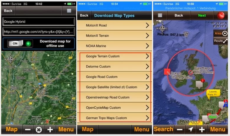
The App MotionX and to be able to download huge areas of Google Maps and Satellite-Imagery is absolute unique to the iOS (iPhone, iPad) for offline purpose.
There are for shure ways to use offline satellite Imagery on any OS, but nowhere it is that easy within MotionX. The App is here the key, not the brand of the hardware 
But not anyone want a capable offroad navigation 
Independent of the Tablet-Brand and OS there are some apps to mention here:
The Navigation with Maps.me is Openstreetmaps based and you can download sorted after country - for free. And it has routing:

Here I wrote an short review in english:
4x4tripping: Navigation for worldtrips - maps.me
For holiday purpose or an word trip the routing is ok. Quite ok. For a more professional but affordable solution I would recommend Sygic.
For shure TomTom and Navigon are better, but they cover much less of the world and if you had to buy 15 Countrys or more you have to spend a lot of bucks. Sigh covers near the whole word.
Sygic and Maps.me are available for iOS and Android. All mentioned Apps are working offline (without cell coverage or Internet).
Surfy
|
1 Jun 2015
|
|
Registered Users
Veteran HUBBer
|
|
Join Date: Mar 2007
Location: UK
Posts: 4,343
|
|
There are masses of apps on the market nowadays.
Such as in this recent thread which came up with another one that is new to me.
http://www.horizonsunlimited.com/hub...-offline-82150
The Android ones on the market increasingly tend to rely on OSM for their information and then append a "skin" to give it their own branding.
On my tablet I guess I have about 5-6 different apps loaded just to experiment with, but I haven't bothered for a while.
Most recently loaded was the app "Russian Military Maps" which claims to cover the whole world (and why wouldn't they).
The app display is instantly switchable between various mapping including RMM, OSM, Bing maps and Open Cycle Maps + a few others that I don't recall at present.
__________________
Dave
|
|
Currently Active Users Viewing This Thread: 1 (0 Registered Users and/or Members and 1 guests)
|
|
|
 Posting Rules
|
You may not post new threads
You may not post replies
You may not post attachments
You may not edit your posts
HTML code is Off
|
|
|
|

Check the RAW segments; Grant, your HU host is on every month!
Episodes below to listen to while you, err, pretend to do something or other...

2020 Edition of Chris Scott's Adventure Motorcycling Handbook.
"Ultimate global guide for red-blooded bikers planning overseas exploration. Covers choice & preparation of best bike, shipping overseas, baggage design, riding techniques, travel health, visas, documentation, safety and useful addresses." Recommended. (Grant)

Led by special operations veterans, Stanford Medicine affiliated physicians, paramedics and other travel experts, Ripcord is perfect for adventure seekers, climbers, skiers, sports enthusiasts, hunters, international travelers, humanitarian efforts, expeditions and more.
Ripcord Rescue Travel Insurance™ combines into a single integrated program the best evacuation and rescue with the premier travel insurance coverages designed for adventurers and travel is covered on motorcycles of all sizes.
(ONLY US RESIDENTS and currently has a limit of 60 days.)
Ripcord Evacuation Insurance is available for ALL nationalities.
What others say about HU...
"This site is the BIBLE for international bike travelers." Greg, Australia
"Thank you! The web site, The travels, The insight, The inspiration, Everything, just thanks." Colin, UK
"My friend and I are planning a trip from Singapore to England... We found (the HU) site invaluable as an aid to planning and have based a lot of our purchases (bikes, riding gear, etc.) on what we have learned from this site." Phil, Australia
"I for one always had an adventurous spirit, but you and Susan lit the fire for my trip and I'll be forever grateful for what you two do to inspire others to just do it." Brent, USA
"Your website is a mecca of valuable information and the (video) series is informative, entertaining, and inspiring!" Jennifer, Canada
"Your worldwide organisation and events are the Go To places to for all serious touring and aspiring touring bikers." Trevor, South Africa
"This is the answer to all my questions." Haydn, Australia
"Keep going the excellent work you are doing for Horizons Unlimited - I love it!" Thomas, Germany
Lots more comments here!

Every book a diary
Every chapter a day
Every day a journey
Refreshingly honest and compelling tales: the hights and lows of a life on the road. Solo, unsupported, budget journeys of discovery.
Authentic, engaging and evocative travel memoirs, overland, around the world and through life.
All 8 books available from the author or as eBooks and audio books
Back Road Map Books and Backroad GPS Maps for all of Canada - a must have!
New to Horizons Unlimited?
New to motorcycle travelling? New to the HU site? Confused? Too many options? It's really very simple - just 4 easy steps!
Horizons Unlimited was founded in 1997 by Grant and Susan Johnson following their journey around the world on a BMW R80G/S.
 Read more about Grant & Susan's story
Membership - help keep us going!
Horizons Unlimited is not a big multi-national company, just two people who love motorcycle travel and have grown what started as a hobby in 1997 into a full time job (usually 8-10 hours per day and 7 days a week) and a labour of love. To keep it going and a roof over our heads, we run events all over the world with the help of volunteers; we sell inspirational and informative DVDs; we have a few selected advertisers; and we make a small amount from memberships.
You don't have to be a Member to come to an HU meeting, access the website, or ask questions on the HUBB. What you get for your membership contribution is our sincere gratitude, good karma and knowing that you're helping to keep the motorcycle travel dream alive. Contributing Members and Gold Members do get additional features on the HUBB. Here's a list of all the Member benefits on the HUBB.
|
|
|


 Hybrid Mode


