|
Satellite annotation of dust event
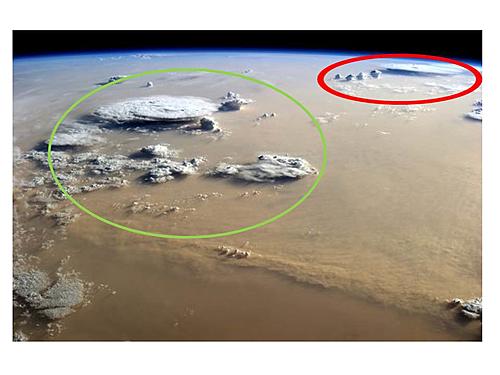
Interesting image of the dust storm taken from the ISS. I have wanted to track down the source of the dust event for a while now, but the satellite images were missing from our usual dust archive. Finally a colleague downloaded the data and processed it for me yesterday.

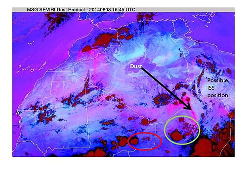
The image above is the image Chris posted last year. I have added green and red circles which map out the two thunderstorm clusters evident in the geostationary satellite image below.

The image from 8 August 2014 at 1645 has a very rough possible position of the ISS from where the oblique photo was taken. The black arrow points to the line of dust which in this satellite product shows up as pink. There is quite a lot of older dust strung out along the Algerian/Mali border. You can see where the closer thunderstorm cluster (ringed in green) is relative to the red ringed cluster. In this satellite product deep thunderstorms show up in a red colour.
The dust event shown in the image began as a set of storms that first became evident on the 15-minute satellite data at 1215 on 7 August 2014 over the Air mountains in northern Niger. The storms merged into a mesoscale convective complex by 1645 on 7 August and by 2130 had issued a huge downdraft of cold air. These downdrafts are formed when rainfall at cloud base evaporates into the very, very dry Saharan air. The cloud base is normally about 5km high - which is very much higher than storms elsewhere in the world. All or very nearly all of the rainfall evaporates before it reaches the ground. The evaporation leads to latent heat being lost from the air (so as to move water from a lower energy state as a liquid to a higher energy state as a gas) and that in turn leads to cooling. The air gets cold compared to its surrounds where there is no evaporation of rain happening and the cold air falls to the surface. From there it rolls across the desert surface as a density current for hundreds of kilometers, just like the movie footage Sam uploaded from southern Algeria. The cold air has winds of about 16m/s and deflates dust from the desert surface. I will upload some of these images of the event being born when I get a moment.
We ran a project in the Sahara to study this kind of thing. The project, called Fennec, put instruments on the ground in many parts of the remote desert, including SW Algeria and NE Mauritania. We also had a research aircraft to fly over the top of the stuff. We flew over N Mali in June 2012. All in all it was a difficult project because of the politics at the time.
|