For folks headed up to Yakutsk and Magadan there is another way to get there over the standard (boring) route that runs between Chita - Skovorodino - Tynda - Yakutsk. The Vilyuisky Trakt has been upgraded in the last year or so, as some pan asian youth sporting event was held this year in Vilyuisk. The previously grim bit between Vilyuisk and Berdigestyakh has been refined and the Vilyuisky Trakt is now feasible. The road is open!

The track is unpaved, and like all unpaved roads in Siberia, the ease of passage has much more to do with the recent weather than the actual condition of the road. Even major Federal Roads like the M56 from Skovorodino to Yakutsk can be hell after a week of rain. We rode the track in 3 days. Its about 1400 km from Lensk to Yakutsk ... The first part of the road from Lensk to Mirny is actually called the Anabar Road, and about 15 km before Mirny you turn right onto the Vilyuisky Trakt.
There is a sandy stretch for 40 km or so to the west of Vilyuisk, the rest is, in good weather, just a regular garden variety dirt road. Any bike will do this road, including the larger GSs and Africa Twins. Some sand and gravel experience would help, but is certainly not necessary.

Fuel is no problem, tho some of the stations occasionally run out of fuel and others have only 80 or 76 octane. From west to east 92 octane is available at Lensk, Mirny, Suntar, Nyurba, VerkhneVilyuisk, Vilyuisk, Khampa, Orto-Surt, Berdigestyakh, Magaras and Yakutsk. The only lonely stretch with some distance between settlements is about 110 km from Novy (near Almazny) to Krestyakh. That same stretch has two water crossings, that should be served by ferry trucks or be fordable.

Mobile phone coverage is best on the MTS or Megafon networks ... only in the larger towns. Suntar, Nyurba, Verkhnevilyuisk and Vilyuisk all had coverage, as well as Lensk, Mirny and Yakutsk of course.
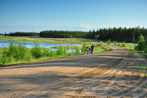
The road is in many parts very scenic ... between Suntar and Vilyuisk its very much like Finland or Estonia. I will link in some pics below.

There are 5 river crossings served by barge ... 4 across the Vilyui river and one across a major tributary, the Markha. Typically the ferry fees are 100 - 150 rubles, but I think we paid only once. All the other times the ferrymen looked at us, and gave us free passage. The ferry's can suck a huge amount of time out of progress. Many of them run only when full. The quietest stretch is that between Almazny and Suntar and the ferry at Krestyakh can make you wait 5 hours or more.
Theoretically its 1000 rubles !!! to take a load across the river at Novy (Almazny) on the trucks ... again you may get a freebie, or not.

Ethnically, Lensk and Mirny are very Russian, while the Vilyui river towns are almost exclusively Yakut. Its a very comprehensive view of Yakutia. No-one we spoke to had ever seen a foreigner in the region before, let alone on a motorcycle ... accordingly we had terrific hospitality. Cafe's giving us free food, and or free accomodation, ferry's refusing payment.

Fuel (and food) is in general not cheap out this way. We were typically paying 28 - 29 rubles a litre. It was 23 a litre in Ust Kut, and about 18 a litre at the same time in Moscow.
Weather in Yakutia in summer is very much centred on Yakutsk ... the closer you are to Yakutsk, the better the weather. There is typically a huge high pressure system that sits over Yakutsk in summer and for weeks on end Yakutsk has pure cloudless blue skies, 20+ hours a day or sunshine and 30-32 degree temperatures. The western part of Yakutia (Mirny Udachny, Lensk) is not naturally as blessed and rain is more common there.
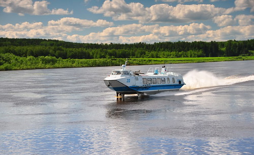
Access to the region and the start of the Vilyuisky Trakt is by barge from Ust Kut. It takes 3 days and apparently there is one every 3-4 days. We were lucky, arriving one evening and being on a barge by 1pm the next day. There are also daily hydrofoils doing the 1000 km river trip from Ust-Kut to Lensk, and it may be feasible for a solo biker to persuade the hydrofoil "raketa" in russian, to take a motorcycle on the hydrofoil (normally passengers only). The hydrofoils take less than 1 day to do the same trip.
Hydrofoils leave from the main rechnoi port (river port) but the barges leave from across the river from a makeshift ramp. Its very tough to find so I will put the GPS co-ordinates here: N 56° 47.288' E 105° 46.701'.
- - -

The fast way - river hydrofoil

Passing other barges in the night ... twilight on the Lena River at midnight

The road heading North out of Lensk

Road conditions are weather dependent ... we were lucky .. this is 2 days after the rain finished.

Between Suntar and Vilyuisk ... could be Estonia and Finland

Again, between Suntar and Vilyuisk

The toughest bit of the road, about 40 km of sandy conditions immediately to the west of Vilyuisk