 |

7 Feb 2012
|
 |
Registered Users
New on the HUBB
|
|
Join Date: Nov 2008
Location: Tokyo, Japan
Posts: 15
|
|
 Is it possible to ride from Magadan to Petropavlovsk-kamchatsky?
Magadan to Petropavlovsk-kamchatsky: Is this even remotely possible by the most skillful off-road riders in the best weather conditions, or is it a total impossibility?
__________________
1997 Honda X4 ・ 2009 BMW R1200GS Adventure ・ IBA #42657
|
7 Feb 2012
|
|
Registered Users
HUBB regular
|
|
Join Date: Aug 2010
Location: Timisoara
Posts: 77
|
|
Hi,
the general answer is to my knowledge NO!
For more info try this topic on advrider. If there are some who can the polish team lead by Lord Maciek has the answer:
3 x KTM GO EAST - Page 76 - ADVrider
Safe rides
Adrian
|
7 Feb 2012
|
|
Gold Member
Veteran HUBBer
|
|
Join Date: Jan 2002
Location: Toronto, Canada
Posts: 2,134
|
|
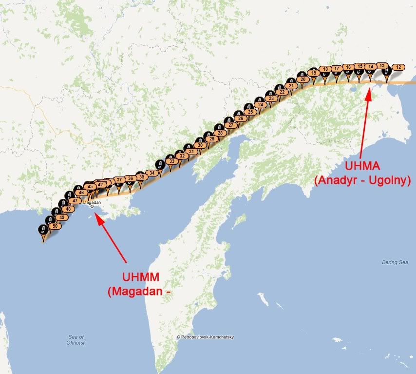
Last week, I flew a small aircraft from Anadyr (way up in the north) to Magadan, then south to Vladivostok. I didn't see any roads of any kind north of Magadan - not even logging roads or trails. The track below shows my path, with Magadan at the bottom. I also did not see any roads leading south from Anadyr. Additionally, I did not see any evidence at all of habitation between these two cities, beyond about 20 to 25 miles from the start and finish of the flight.
So, I think it would not be possible to make such a trip on a motorcycle.
Michael
|
7 Feb 2012
|
|
Registered Users
Veteran HUBBer
|
|
Join Date: Dec 2006
Location: Moscow
Posts: 1,117
|
|
You see from Adrian's link above the difficulties Mac had going east then north of the RoB. If Swinarski can’t make progress there, no one can! They had to do a massive detour of the whole area to get to Anadyr. 666 MotoSyberia Czyste Zlo
Part of Colebatch’s 2009 plan was to get further east on a moto than anyone before. We knew that we could probably reach Merenga to claim this and possibly on to the sea coast. There were fish farms there (licenced and/or illegal) and they needed routes to get the fish out to markets. We also knew the CoastGuard/Police/Customs patrol this coast from the sea looking for illegal farms, so access to the sea was a probable route for the illegal trade.
However a few days before getting to the area we learned Swinarski and team had just done it, taking away our possible ‘first’ so we didn’t follow that target anymore. Talking to Greg, their ‘retiring’ member we met in Magadan, I felt quite relieved!
That is just getting east of the RoB. There is talk of soon extending the RoB Federal road system to Anadyr and also vague chatter of a possible tunnel to Alaska in the very long term. Such a road may help, but not for Kamchatka itself.
The Kamchatka peninsular has its own difficulties.
Firstly. The whole of Kamchatka was a closed military area. Closed to everyone, Russian or foreigners alike. The only people allowed to be there being military personnel posted there and their families plus a few indigenous people. This was relaxed a little with a permit application system and in more recent times the southern parts have had the restrictions removed, but I understand they are still in place further north. Added difficulties would be the natural protected area status.
Secondly. I looked briefly at the idea a while ago, but quickly gave up. Looking at contour maps of the ismuth I concluded it to be totally impassible (and I am not known for negativity as some will confirm).
At the narrowest point it is less than 90km across, from coast to coast. The mountains forming the ismuth are up to 2500m high with many rivers running down both sides, some depicted very wide.
With those dimensions of height and width I concluded it to be a very steep bit of land ruling out even zimnik winter roads. In summer, with that gradient, the rivers would be very fast flowing and therefore deep and rocky - and all going through big old volcanic rock formations
I gave up thinking about it as possible to reach by land. The only way to Kamchatka remains air and sea.
Of maybe foot?
|
7 Feb 2012
|
|
Registered Users
Veteran HUBBer
|
|
Join Date: Dec 2006
Location: Moscow
Posts: 1,117
|
|
Quote:
Originally Posted by PanEuropean

Last week, I flew a small aircraft from Anadyr to Magadan, ... I didn't see any roads of any kind north of Magadan - not even logging roads or trails.
|
There may be a zimnik or two - winter only routes for when mud has frozen hard and then covered with snow/ice .
As it is hard winter right now (this evening -34C in costal Anadyr, probably colder inland), would you have been able to pick these out from above, in all the white?
Quote:
Originally Posted by PanEuropean
The track below shows my path, with Magadan at the bottom.
|
 You got a bladder problem?
Lots of stops!
Must be the cold! 
|
10 Feb 2012
|
|
Gold Member
Veteran HUBBer
|
|
Join Date: Jan 2002
Location: Toronto, Canada
Posts: 2,134
|
|
Quote:
Originally Posted by Tony P
TAs it is hard winter right now (this evening -34C in costal Anadyr, probably colder inland), would you have been able to pick these out from above, in all the white?
|
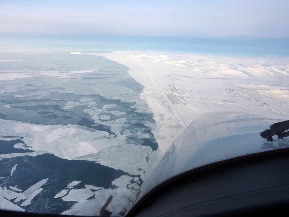
Yes, I think so. I flew at an average altitude of 8,000 feet above the ground, which is quite low (the aircraft I was moving is not pressurized). From that altitude, it is quite easy to pick out features on the ground, such as tracks, paths, and (with certainty) roads. The temperature the day I left Anadyr was -38°, at that temperature, there is virtually no moisture in the air, the air is very clear and visibility is excellent.
It was not permitted to have a camera in the cabin of the aircraft while transiting Russia (the cameras had to be locked up in the baggage in the hold of the aircraft). So, I could not take any pictures. But I did write a little blog about the flight on an aviation website, it is here, and there are some pictures of Anadyr, Magadan, and Vladivostok posted.
Below is a picture I took of Nome, Alaska, just before entering Russia. You can see the roads and trails quite clearly.
Nome, Alaska
Michael
|
10 Feb 2012
|
|
Registered Users
Veteran HUBBer
|
|
Join Date: Dec 2006
Location: Moscow
Posts: 1,117
|
|
|
Michael.
Thank you.
Having done a little PPL class work 20 years ago (Thom still the standard?) going through your interesting link made my brain ache at the prospect of if I had continued!
The air fields you saw between Anadyr and Magadan would be the only means of access to the small communities there other than rivers which become zimniks in winter.
They are still sensitive about photos in those parts. I got ordered to put my camera away when I wanted to take souvenir photos of Magadan public passenger terminal while walking to the plane for a commercial flight to Vlad. Old habits die hard.
Interesting. Thanks again.
|
|
Currently Active Users Viewing This Thread: 1 (0 Registered Users and/or Members and 1 guests)
|
|
|
 Posting Rules
|
You may not post new threads
You may not post replies
You may not post attachments
You may not edit your posts
HTML code is Off
|
|
|
|

Check the RAW segments; Grant, your HU host is on every month!
Episodes below to listen to while you, err, pretend to do something or other...

2020 Edition of Chris Scott's Adventure Motorcycling Handbook.
"Ultimate global guide for red-blooded bikers planning overseas exploration. Covers choice & preparation of best bike, shipping overseas, baggage design, riding techniques, travel health, visas, documentation, safety and useful addresses." Recommended. (Grant)

Led by special operations veterans, Stanford Medicine affiliated physicians, paramedics and other travel experts, Ripcord is perfect for adventure seekers, climbers, skiers, sports enthusiasts, hunters, international travelers, humanitarian efforts, expeditions and more.
Ripcord Rescue Travel Insurance™ combines into a single integrated program the best evacuation and rescue with the premier travel insurance coverages designed for adventurers and travel is covered on motorcycles of all sizes.
(ONLY US RESIDENTS and currently has a limit of 60 days.)
Ripcord Evacuation Insurance is available for ALL nationalities.
What others say about HU...
"This site is the BIBLE for international bike travelers." Greg, Australia
"Thank you! The web site, The travels, The insight, The inspiration, Everything, just thanks." Colin, UK
"My friend and I are planning a trip from Singapore to England... We found (the HU) site invaluable as an aid to planning and have based a lot of our purchases (bikes, riding gear, etc.) on what we have learned from this site." Phil, Australia
"I for one always had an adventurous spirit, but you and Susan lit the fire for my trip and I'll be forever grateful for what you two do to inspire others to just do it." Brent, USA
"Your website is a mecca of valuable information and the (video) series is informative, entertaining, and inspiring!" Jennifer, Canada
"Your worldwide organisation and events are the Go To places to for all serious touring and aspiring touring bikers." Trevor, South Africa
"This is the answer to all my questions." Haydn, Australia
"Keep going the excellent work you are doing for Horizons Unlimited - I love it!" Thomas, Germany
Lots more comments here!

Every book a diary
Every chapter a day
Every day a journey
Refreshingly honest and compelling tales: the hights and lows of a life on the road. Solo, unsupported, budget journeys of discovery.
Authentic, engaging and evocative travel memoirs, overland, around the world and through life.
All 8 books available from the author or as eBooks and audio books
Back Road Map Books and Backroad GPS Maps for all of Canada - a must have!
New to Horizons Unlimited?
New to motorcycle travelling? New to the HU site? Confused? Too many options? It's really very simple - just 4 easy steps!
Horizons Unlimited was founded in 1997 by Grant and Susan Johnson following their journey around the world on a BMW R80G/S.
 Read more about Grant & Susan's story
Membership - help keep us going!
Horizons Unlimited is not a big multi-national company, just two people who love motorcycle travel and have grown what started as a hobby in 1997 into a full time job (usually 8-10 hours per day and 7 days a week) and a labour of love. To keep it going and a roof over our heads, we run events all over the world with the help of volunteers; we sell inspirational and informative DVDs; we have a few selected advertisers; and we make a small amount from memberships.
You don't have to be a Member to come to an HU meeting, access the website, or ask questions on the HUBB. What you get for your membership contribution is our sincere gratitude, good karma and knowing that you're helping to keep the motorcycle travel dream alive. Contributing Members and Gold Members do get additional features on the HUBB. Here's a list of all the Member benefits on the HUBB.
|
|
|


 Linear Mode


