 2Likes 2Likes
-
 1
Post By
1
Post By
-
1
Post By LifeRemotely
 |

19 Oct 2012
|
|
HU Meeting Organiser
Veteran HUBBer
|
|
Join Date: Mar 2007
Location: North Ireland
Posts: 102
|
|
Really enjoyed this post.  Great pics. 
Been thru South America on two wheels (twice!) Now you got me thinking about 4 wheels 
Bookmarked for future updates and I will be doing similar with your blog. 
|
19 Oct 2012
|
|
Registered Users
New on the HUBB
|
|
Join Date: Oct 2012
Location: Driving the Pan Am to Argentina from Seatte
Posts: 11
|
|
Thanks Guys. More updates to follow real soon. We just finished driving the worlds most dangerous road in Bolivia called Ruta de Muetre (Route of Death). The drive is stunning and the road in pretty good condition.

The sad part was all the crosses dotting the road marking the spot where someone went over the cliff.
Anyway we are off to the Salt Flats here in Bolivia to take some fun photos and some star shots.

This one was taken in Peru, But since Bolivia has lest power the sky should be clearer 
Stay tuned and Follow us on Facebook for more updates!
|
2 Nov 2012
|
|
Registered Users
New on the HUBB
|
|
Join Date: Oct 2012
Location: Driving the Pan Am to Argentina from Seatte
Posts: 11
|
|
|
Driving Bolivia's Death Road

Start: October 15, Sorata
Finish: October 23, Uyuni
Death Roads Survived: 1
Fluffy Things Made From Alpaca Bought By Jessica: 3
Bolivian Capitol Cities Camped In: 2
Likelihood of Kobus Ever Wanting to Drive in La Paz Again: Nada
This week we pass through both of Bolivia's capital cities. La Paz, the administrative center and highest capital city in the world, and Sucre, Bolivia's judicial and cultural capital and certainly the most beautiful and welcoming city in Bolivia. In between, we stop over in the towns of Oruro and Potosi, mining towns that are attempting to retain some of their previous golories, with limited success.
The highlights of our week were finding a fantastic campsite in the town of Coroico and driving the death road connecting Coroico to La Paz, proclaimed by many to be the most dangerous road in the world.

From the oasis paradise in Sorata we head towards La Paz, the seat of Bolivia's government. En route we pass some spectacular mountains and cross through more endless miles of Altiplano landscape consisting of rocky hills and scrubs.
Entering El Alto, a large suburb of La Paz, our gas light starts to flicker on. We've heard of trouble buying gas in Bolivia, but what we found in El Alto was beyond our comprehension. After stopping at eight gas stations we finally found one that would sell us five liters of gas, enough to get us into the city, and that was only after Kobus offered up his firstborn son, left arm and right leg.
Gas is subsidized in Bolivia, similar to Ecuador, except Bolivia recently passed laws which require foreign-plated vehicles to pay three times the local price. A difference of $3 per gallon. The sale of gas is strictly regulated and gas stations must jump through some hoops and posses the proper paperwork or computer systems to record gas sold to foreigners.
Many of the stations we stopped at flat out refused to sell us gas, even though they had everything required, they were simply too lazy to do the work. After a bit of trial-and-error we figured out to haggle for a lower price, a mere two times the local price, by asking for the attendant to forget about the paperwork. This worked about 75% of the time once we left La Paz.

In La Paz, we camped at Oberland Hotel, which is about 15 minutes from the city center. It was obviously a popular spot for European overlanders (we met six groups in two nights) but wasn't all that great for tent camping, being essentially a parking lot for unimogs.
Our goals in La Paz involved getting in, shopping for some gear, and getting the hell out. Tourist activities were not on the todo list. Our main mission was to hunt down on propane for our stove, which proved impossible. Our choice was to buy a 25lb tank for our Coleman stove, or a new backpacking stove that ran on small butane cannisters. We went with the a new cheap stove, and hope to be able to find small propane bottles in Chile or Argentina in the coming weeks.

After a night in La Paz, and some frantic shopping for fuel, both for our car and our stove, we hit the road to Coroico which lies several hours east of La Paz, in the general direction of the Amazon. Situated at about 4000 feet, versus La Paz at 12,000, we welcomed the warmer temperatures and greenery.

Tipped off by a few overlanders we met in Peru, we stopped at Sol y Luna where the camping proved to be excellent. It's not often we find our tents on grass, our own covered area for cooking and escaping the sun, a fire pit for grilling and (most importantly) hot showers!

The only downside (or upside if you're Kobus) were the extraordinary variety of insects. We saw a few big spiders, more moths than you could count, several hundred of which died in our campfire each night, and our old nemisis the botlas fly. Oh well, we haven't doused ourselves in DEET since Machu Picchu so I'm sure the chemical side-effects have worn off by now.

Coroico and La Paz are connected by two roads, one is a newly-paved highway that spirals through the mountains. And the other is a narrow gravel road responsible for killing around 200 people each year.
After talking to other overlanders who suggested we drive The Death Road and are much older and drive larger vehicles than us, we couldn't logically think of a reason not to give it a shot.

From Coroico it's over 40 miles to the junction with the main paved highway leading to La Paz. Those miles pass through tropical cloud forests and run along very steap mountain cliffs. The views into the valley are spectacular, if you can stand the vertigo-enducing look out into nothingness.

Towards the top the road becomes more narrow and includes quite a few blind corners. Looking at this, it's not hard to see how a bus could plunge off the side. From the "guardrail" in this picture to the bottom of the valley is easily over 1,500 feet. And it's safe to assume that guardrail exists because someone didn't make it around that corner.
[IMG]liferemotely.com/images/stories/articles/bolivia-2/9-cross.jpg[/IMG]
The roadside is lined with memorials with names and dates of those who met their maker on this road. Not all of the names are obviously Latin American, and plenty of the dates are from the past decade. If that doesn't serve to keep you focused on the road, there's not much that will.

There are a few helpful signs along the way, as a nod at general safety awareness in case you missed the five dozen road-side altars. This sign informs the safety-conscious motorist to stay to the left. We're driving on the right side of the road. Something about the combination of fog, blind corners, 1,000 foot cliffs and vehicles driving on the same side of the road in opposite directions that does not exactly strike me as a good idea.
Keep Reading >>>
|
13 Nov 2012
|
|
Registered Users
New on the HUBB
|
|
Join Date: Oct 2012
Location: Driving the Pan Am to Argentina from Seatte
Posts: 11
|
|
|
Bolivia's Southwest Circuit

Start: October 26, Uyuni, Bolivia
Finish: October 29, San Pedro de Atacama, Chile
Highest Altitude Camped At: 15,600 Feet
Overnight Low: 22F
Flamingo Species Seen: 3
Colors of Lakes Photographed: Blue, Green, White and Red
There haven't been too many times on this trip where we've felt that we've been really out there. The Corcovado jungle in Costa Rica definitely rings a bell, maybe hiking the narrows in Zion National Park, or our recent overnight visit to the Uyuni Salt Flats.
One thing is certain, we've never had to carry gas on our roof to get where we've needed to go, and we've never spent more than 48 hours without our wheels touching asphalt. Maybe we've been doing it wrong, or maybe we just had our our biggest adventure yet.
There are no medical facilities or mechanics; no ready-made food or comfy hotels in this part of the world. Bolivia's southwest circuit is raw, unadulterated adventure at incredibly high elevations that a single traveler pays hundreds of dollars to experience. The three of us spent a total of $65 to enter the park, $50 on gas, $30 on food and $25 on alcohol. I've said it before, and I'll say it again: this is why we overland.
We're going to try something a bit different with this trip update and include as much information about the route, road conditions and preparations as possible. So if I'm rambling on about gasoline availability and you're looking at a picture of a fluffy bunny, don't be alarmed.
We weren't originally going to attempt to drive the Southwest Circuit, but after some deliberations and excellent advice from Pan-Am Notes' 2010 trip, and our friends at From A to B who did the drive days before us, we decided to give it a shot. If you are contemplating heading into Bolivia's wild frontier, check out Pan-Am Notes' article, and From A to B's new report, they include all of the GPS way points you will need.

Unless you are in a hurry, it's best to explore the salt flats first and then return to Uyuni to stock up on gas and supplies. It's also worth it to get the undercarriage of your car washed clean from the salt. There is a great place on the south side of Uyuni that will clean the underside and the rest of your car for Bs50. S20 28.156 W66 49.172
There is gas in Uyuni, but nowhere else between there and San Pedro de Atacama. We drove 280 miles from Uyuni to San Pedro, but we took the shortest route. Others drove 300 miles by the westerly route, and up to 400 if you want to include the salt flat as well.
There is sometimes gas in San Cristobal, but it is unreliable. The last five overlanders we spoke to going north said there was no gas available in San Cristobal.
There are three gas stations in Uyuni. The one on the east side of town, on the main road when you come in from Potosi, will sell gas to foreigners. Tell them you want it “sin factura” and insist that yesterday you paid 5 Bolivianos per liter. That should get you the best deal. Count on your fuel efficiency dropping due to a combination of high elevation and gravel roads.

The road from Uyuni to Alota (via San Cristobal) is nicely graded dirt - we were going 60mph. South from Villa Alota to Villa Mar the road is still in good shape but there are some patches of sand, and there is a small river crossing just as you leave Villa Alota, less than 6” deep. Given the state of the rainy season, this may change. We were there at the end of the dry season.
From Villa Mar we turned off to the southwest to head towards Laguna Colorado. This road is a bit bumpier then the previous, and again there are some rough spots and places where high clearance makes things easier. We still averaged 30mph up to the lake. We made it from Uyuni to Laguna Colorado in about five and a half hours.
The roads in the park are mixed, mostly rough dirt and some very bad corrugation. There are lots of tracks and usually alternate routes around patches of deep sand and soft gravel. If you were careful, you could do this route without a high clearance 4x4. But expect lots of backing up and a lots of route finding. Deep sand is the biggest problem.

There is a park office on both sides of Laguna Colorado. The park entry fee is Bs150 per person, and the ticket is valid for four days. There is another office on the southern border a few kilometers before the Bolivian immigration. They will check your tickets, so don’t overstay your four days.

We spent our first night camped in a dry canyon just off the main road leading south from Laguna Colorado. Most of this park is at very high altitude and the weather is freezing, below 0C at night, easily. On top of the frigid temperature there are very high winds that are not friendly, especially if you are sleeping in a tent. Plan your campsites to be in sheltered areas, and you’ll enjoy the park more.

Betcha didn't know rabbits could have long tails?

This is a vicuña, a wild variety of llama that lives at high elevations. We've only ever seen them licking rocks in the middle of a desert. But they must be doing something right, a kilogram of their fur sells for $500 and the right to cultivate them has sparked bloody feuds in parts of Bolivia and Peru.
Keep Reading>>>
|
26 Nov 2012
|
|
Registered Users
New on the HUBB
|
|
Join Date: Oct 2012
Location: Driving the Pan Am to Argentina from Seatte
Posts: 11
|
|
|
Bolivia Salt Flat Shenanigans

Start: October 24, Uyuni
Finish: October 26, Uyuni
Miles Driven on Salt: 120
Goofy Pictures Taken: 147
Godzilla Attacks: 3
Bottles of Rum That Are Always Gone: 2
The Salar de Uyuni is the world's largest salt flat, covering an area of over 4,000 square miles. At almost 12,000 feet, it's a bleek, desolate and absolutely beautiful place to do a bit of off-road driving.
It also happens to be one of the few places where it's possible to to take ridiculously out-of-perspective photos without the help of a green screen or photoshop. And we promise that neither of those were used in the making of this blog post...

The town of Uyuni fit our expectations after hearing about it from other travelers. A run-down dusty hole of a place with little to do or see aside from the salt flats. Luckily we were able to find a cheap hotel that looked a bit better than this crumbling public bathroom.

As if the rubble-strewn streets weren't enough, they had to go and place a few creepy metal statues along the main thoroughfare. Fortunately we only had to spend two nights in Uyuni, one before and one after we venture out into the salt. We wouldn't have lasted long in any case, there were absolutely zero wifi signals in the entirety of the town.

The white stretch just visible on the horizon was a welcome sign after driving the six-mile stretch of horribly corrugated road leading up to entrance of the salt flats. Salt is harvested in Uyuni to the tune of many thousands of tons per year. Luckily there doesn't seem to be much risk of running out in our lifetime.

After driving fifty miles into the salt flats we reach the first of several cactus-covered "islands" called Isla Incahuasi. Kobus begins the photo taking by snapping a few dozen pictures of Jessica as we head to check out he cactus forest.

Kobus posed next to this monstrous cactus. We are told they grow about one inch per year, making this guy roughly as old as the United States.

Jessica, the professional photographer, is never one to pose nicely for pictures. Things get a bit dicey when she pulls up a salt shard and makes ready to stab the next person who takes her picture.

Realizing that the salt shard stabbing business might be a bit too messy for her tastes. Also, the salt crumbles when you actually try to move it in a swift motion... Jessica retaliates by squishing Kobus who is still snapping away in the distance.

We stop for lunch and to scout out potential campsites at Isla Pescado, a much less crowded alternative to the main island. After chowing down on some quesadillas and our first can of refried beans in months, we head back into the salt to engage in a bit of goofy photography.
http://liferemotely.com/images/stori...9-godzilla.jpg
Godzilla attacks!
Keep reading>>>
|
3 Dec 2012
|
|
Registered Users
New on the HUBB
|
|
Join Date: Oct 2012
Location: Driving the Pan Am to Argentina from Seatte
Posts: 11
|
|
|
The Art of Buying Gas in Bolivia

Buying gas in Bolivia is not only a joke, it's a pain in the butt. Recently Bolivia introduced a gas price for foreign vehicles at about 3 times the local subsidized price to keep neighboring countries from buying cheap gas and going home.
Selling gas to a foreigner involves a lot of paperwork for the attendants which in turn leads to some ridiculous excuses to from lazy attendants.
Here are some common excuses we heard over the 3 weeks spent looking for gas in Bolivia.
- Sorry we do not have international receipts. (Disculpe, pero no hay facturas internacional)
- Sorry we do not have a license to sell gas to a foreign vehicle. (Disculpe, no se vende gasohol por placas extraños)
- Sorry we are out of Gas – this might have been a legitimate excuse (Disculpe, no hay gasohol)
- You can only get a small amount. (Solo, diez litros. Nada mas.)
- The receipts are locked in the office and the person with the keys is off for the day. (Disculpe, no lo tengo facturas. La oficina esta cerrado y no tengo los claves. EL jefe tiene los claves y no esta aqui hoy.)
Our Best Advice
- Always smile and try not to get frustrated, this could prove difficult when you're on empty.
- Say hello and ask how are you before asking for the price of gas without a receipt.
- Negotiate a price before you start filling up.
- If the excuse for not selling is that the manager is there, ask when he leaves.
- Don't ever be desperate for gas. Start looking to fill up when you are a half a tank.
- Don't wait until you are leaving town to fill up. Gas stations frequently run out of gas. If you wait, the chances of being stranded increase.
- When you are desperate:
- Take a jerry can or empty coke bottle and put on your best "I'm desperate" face. Usually you can get a few liters.
- Park your car in front of the pump and tell them you have no gas left so you can't move. They'll "find" the receipts quickly, but be prepare to pay full international price.
Keep Reading>>>
|
22 Jan 2013
|
|
Registered Users
New on the HUBB
|
|
Join Date: Oct 2012
Location: Driving the Pan Am to Argentina from Seatte
Posts: 11
|
|
|
Chile's Lakes District
Start: December 12, Pucon
Finish: December 23, Puerto Montt
Grills Used For One Dinner: 5
Four-Legged Road Blocks Overcome: 2
Days With Rain: 9 of 12
Fish Caught: 0
The weather has finally caught up to us. I can count the number of times we've had more than two consecutive days of rain on one hand. Our time in the Lakes District brought us six consecutive days of rain and a lot of soggy gear. But we're from Seattle, meaning we don't believe in umbrellas, and we know how to shop for good rain jackets.
We did our best to make the most of our time in Chile's Lakes District. We started with a few days spent hanging out with friends old and new that culminated in a barbeque nearly rivaling our Thanksgiving pig roast. From Pucon we drove through the back roads to visit a handful of other lakes and rivers en route to Puerto Montt with the hopes of catching a couple world famous Patagonian trout.
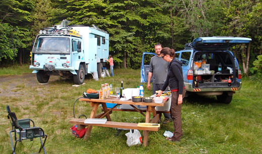
Our campsite in Pucon with our friends Mark and Sarah at FromAtoB.org and their gigantic rig that's aptly named the beast. I've pitched my tent in its shadow a couple times now and can definitely say it makes for a good wind break and gives plenty of shade from that pesky morning sun.
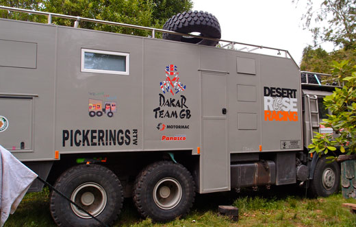
Also in our campsite are the Pickerings at ChaseTheRace.net, a couple from England with their three children. As you can see, this 6x6 monstrocity dwarfs even The Beast and plans to follow the Dakar this year. I can't blame them for the size though. As kids Jessica and I went on an RVing trip across the US and can say from experience that you need a heck of a lot of space when there are youngin's on board.
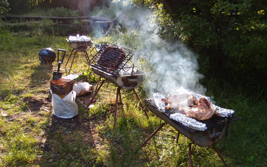
After battling a day of rain, the weather breaks and we wake to sunny blue skies. Perfect weather for a barbeque. Above we have five grills in action, by far the most fire juggling I've ever attempted. Cornbread, potatoes, carrots, corn, peppers, onions, four racks of baby back ribs, one gigantic chunk of pork spare ribs and two whole chickens are on the menu.
To give the adults a bit of peace and quite from the kiddies' shenanigans (often involving a water gun, decided not cheeky or fun in cold weather) Kobus sets off on a mission to teach them how to fish. Small trout are seen, but nothing is brought to shore.
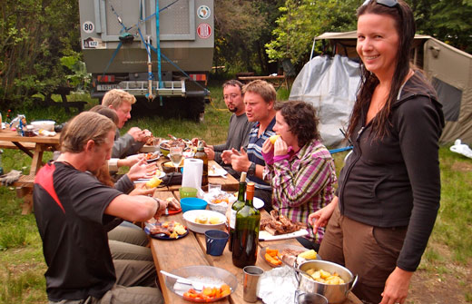
Joining us for our epic dinner along with the Pickerings and Mark and Sarah are two ex-overlanding friends we met in Pucon from South Africa and Australia. They started their trip driving a van but nearly ended with disaster after it caught fire and nearly burned to the ground as a result of brake failure. Luckily no one was injured and they managed to salvage most of their gear and continue the trip as backpackers.
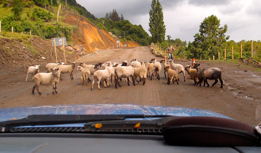
From Pucon we take the back roads towards Lago Ranco following dirt roads through rural Chilean towns. More than once we encounter a Latin American road block, this time in the form of a couple dozen sheep.
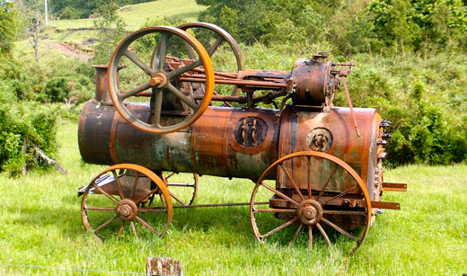
Along the way we also stop to take a picture of this ancient steam engine sitting in a field in the middle of nowhere. Steampunk fans eat your heart out.
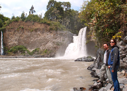
We camped next to another set of waterfalls called Salto del Nilahue near Lago Ranco. It was a short five minute walk down to he falls from our campsite, but it proved impossible to get any closer than we stand above due to the rain-filled river.
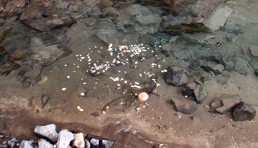
The river bank was coated with pummice rocks which provided a half hour of entertainment for a few bored campers. Floating rocks are fun!
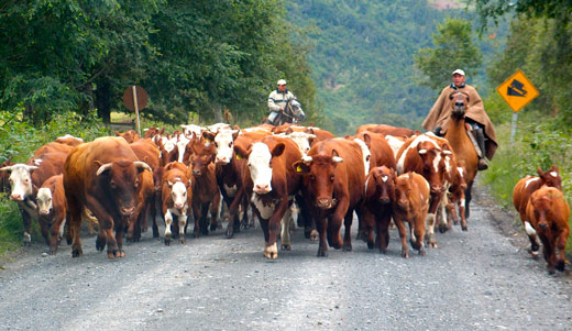
Back on the road to Lago Ranco we hit yet another road block. Kobus wisely pulls over to let the gauchos steer their steers clear of our path.
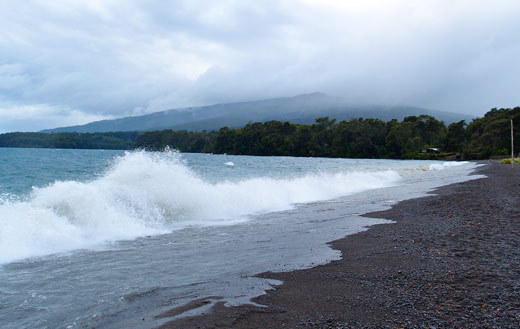
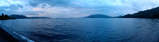
At Lago Ranco we have two of the worst days of weather we've had since leaving Oregon. Above is a shot of Lago Ranco and the two-foot wind-driven waves crashing along the shore. Luckily the campground had shelters with wind breaks and we were able to hole up under cover and spend a day getting work done on our laptops.

For dinner Kobus experimented with a recipe we learned from the Pickerings during our stay in Pucon. They learned it from an Argentinian cookbook and gave us a sample of their first attempt at the recipe. Certainly not the cleanest way to cook a chicken, but the results were good enough that we knew we'd have to give it a shot.

After seasoning and safely wrapping in foil, the chicken is covered with mud and cooked for a couple hours on charcoal. The results were spectacular, as expected, although doing the dishes was decidedly less fun.

After two wet and windy days on Lago Ranco we head to Puerto Montt where we spend a day and half running errands including filling up our propane tank, checking out the ferry schedule for Chiloe and doing a bit of Christmas shopping. The weather in Puerto Montt proved to be no better than farther north, so we hunkered down under our newly purchased tarp and hoped the sun would make an appearance in time for the holidays.
Before heading to Chiloe for Christmas we drove east of Puerto Montt along the start of the Carretera Austral to a campsite on a river. We had hoped to finally catch a couple Patagonian trout. Unfortunately, the rain followed us.
The river was too blown-out to be very good fishing. It rose at least a foot and a half in the day since we arrived, and was moving way too fast for wading or fly fishing. Oh well. At least we got to thoroughly test out our rain gear.
Our last day on the river the campsite host drove by several times to check on us and make sure we were ok. He told us that the rising river was often a problem given where we had camped, and that we should move to higher ground. Eyeballing the water level, I gave us 2-3 feet more until the river was at our doorstep.
It wasn't raining hard, it was just raining frequently, so we decided to wait it out and watch the water level over the next couple hours before deciding to move. Fortunately, after our host returned for the third time and pleaded with us to move, the rain stopped. By the time we woke up in the morning the river was back to its original level.
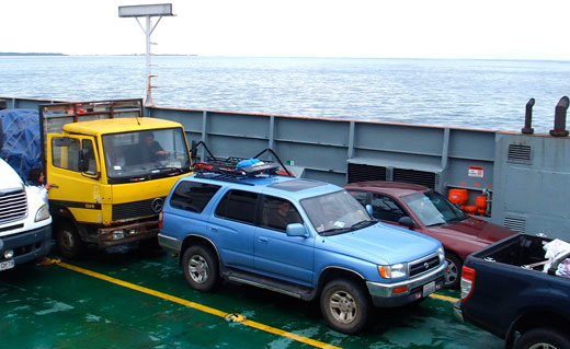
Up next: We load Blue up on a ferry to the island of Chiloe where we spent Christmas in the rain with old and new overlanding friends.
|
|
Currently Active Users Viewing This Thread: 1 (0 Registered Users and/or Members and 1 guests)
|
|
|
 Posting Rules
|
You may not post new threads
You may not post replies
You may not post attachments
You may not edit your posts
HTML code is Off
|
|
|
|
Check the RAW segments; Grant, your HU host is on every month!
Episodes below to listen to while you, err, pretend to do something or other...

2020 Edition of Chris Scott's Adventure Motorcycling Handbook.
"Ultimate global guide for red-blooded bikers planning overseas exploration. Covers choice & preparation of best bike, shipping overseas, baggage design, riding techniques, travel health, visas, documentation, safety and useful addresses." Recommended. (Grant)

Led by special operations veterans, Stanford Medicine affiliated physicians, paramedics and other travel experts, Ripcord is perfect for adventure seekers, climbers, skiers, sports enthusiasts, hunters, international travelers, humanitarian efforts, expeditions and more.
Ripcord Rescue Travel Insurance™ combines into a single integrated program the best evacuation and rescue with the premier travel insurance coverages designed for adventurers and travel is covered on motorcycles of all sizes.
(ONLY US RESIDENTS and currently has a limit of 60 days.)
Ripcord Evacuation Insurance is available for ALL nationalities.
What others say about HU...
"This site is the BIBLE for international bike travelers." Greg, Australia
"Thank you! The web site, The travels, The insight, The inspiration, Everything, just thanks." Colin, UK
"My friend and I are planning a trip from Singapore to England... We found (the HU) site invaluable as an aid to planning and have based a lot of our purchases (bikes, riding gear, etc.) on what we have learned from this site." Phil, Australia
"I for one always had an adventurous spirit, but you and Susan lit the fire for my trip and I'll be forever grateful for what you two do to inspire others to just do it." Brent, USA
"Your website is a mecca of valuable information and the (video) series is informative, entertaining, and inspiring!" Jennifer, Canada
"Your worldwide organisation and events are the Go To places to for all serious touring and aspiring touring bikers." Trevor, South Africa
"This is the answer to all my questions." Haydn, Australia
"Keep going the excellent work you are doing for Horizons Unlimited - I love it!" Thomas, Germany
Lots more comments here!

Every book a diary
Every chapter a day
Every day a journey
Refreshingly honest and compelling tales: the hights and lows of a life on the road. Solo, unsupported, budget journeys of discovery.
Authentic, engaging and evocative travel memoirs, overland, around the world and through life.
All 8 books available from the author or as eBooks and audio books
Back Road Map Books and Backroad GPS Maps for all of Canada - a must have!
New to Horizons Unlimited?
New to motorcycle travelling? New to the HU site? Confused? Too many options? It's really very simple - just 4 easy steps!
Horizons Unlimited was founded in 1997 by Grant and Susan Johnson following their journey around the world on a BMW R80G/S.
 Read more about Grant & Susan's story
Membership - help keep us going!
Horizons Unlimited is not a big multi-national company, just two people who love motorcycle travel and have grown what started as a hobby in 1997 into a full time job (usually 8-10 hours per day and 7 days a week) and a labour of love. To keep it going and a roof over our heads, we run events all over the world with the help of volunteers; we sell inspirational and informative DVDs; we have a few selected advertisers; and we make a small amount from memberships.
You don't have to be a Member to come to an HU meeting, access the website, or ask questions on the HUBB. What you get for your membership contribution is our sincere gratitude, good karma and knowing that you're helping to keep the motorcycle travel dream alive. Contributing Members and Gold Members do get additional features on the HUBB. Here's a list of all the Member benefits on the HUBB.
|
|
|


 Hybrid Mode


