 2Likes 2Likes
-
 1
Post By Schim
-
 1
Post By PatOnTrip
 |

3 Jan 2019
|
 |
Registered Users
New on the HUBB
|
|
Join Date: Jun 2017
Location: Hampshire
Posts: 1
|
|
 Data visualisation of world weather by month
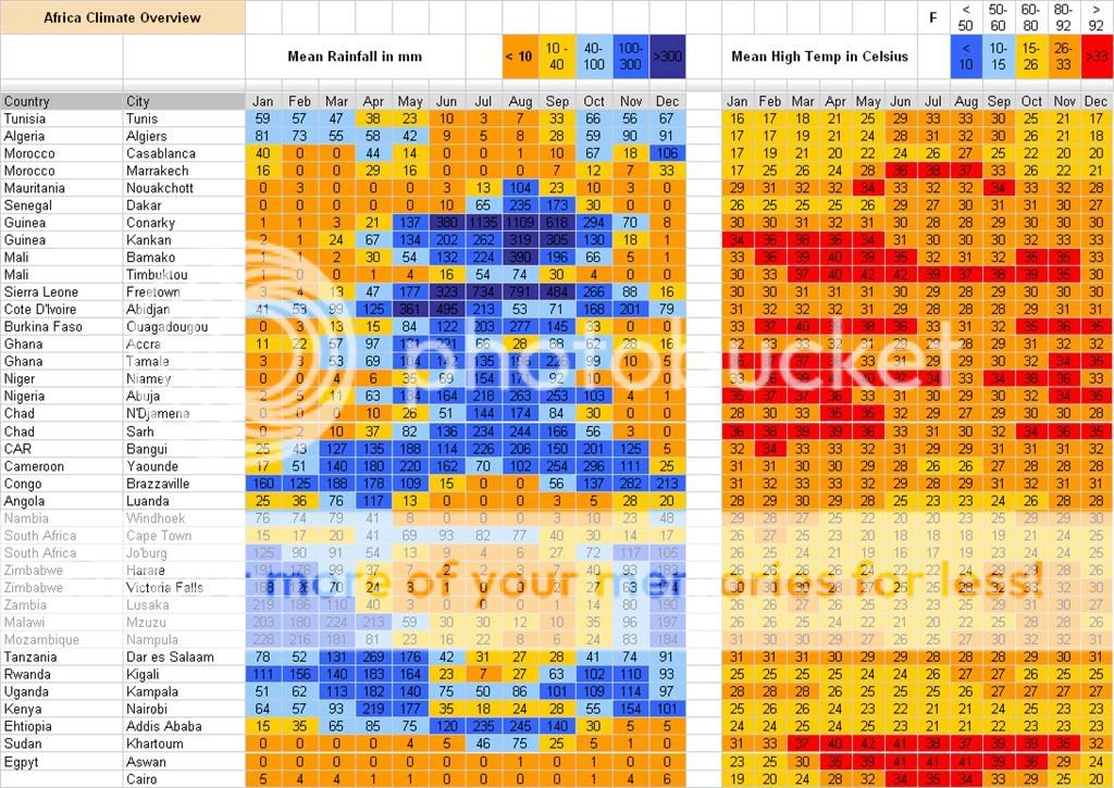
Back in 2009 user Jammin posted a question about Africa Climate Overview (Weather Info)
It contained a Google Docs Spreadsheet with climate info (avg rainfall and high temps) of key African cities
 g
http://spreadsheets.google.com/pub?k...N7xvFkScnqNbXQ
I'm wondering if any travellers have found any online resources where you could user some sort of 'slider' to visualise temperatures/rainfall across the calendar months?
I found a link to someone who is busy creating the 'ClimateList' app, but haven't tried it out, and am loathe to install anything on my mobile.
[IMG]https://cdn-images-1.medium.com/max/800/1*qYjUUIUQYSW8pMZU-FlpZA.gif[/IMG]
See below:
 https://climatelist.com/
My question is probably a bit ambitious but any resources to help decide when to start the trip would help.
|

3 Jan 2019
|
|
Contributing Member
Veteran HUBBer
|
|
Join Date: Mar 2004
Location: Montreal
Posts: 245
|
|
|
Hi Schim,
A way to make your planning easier would be to be able to specify how much weeks you approximate to spend in each countries/cities. Then plot on a chart the rainfall/temperature over time.
How good are you with spreasheet tools ( Excel, Numbers,...)? With the MONTH() and VLOOKUP() functions, it can be done easily.
Patrick
|
|
Currently Active Users Viewing This Thread: 1 (0 Registered Users and/or Members and 1 guests)
|
|
|
 Posting Rules
|
You may not post new threads
You may not post replies
You may not post attachments
You may not edit your posts
HTML code is Off
|
|
|
|

Check the RAW segments; Grant, your HU host is on every month!
Episodes below to listen to while you, err, pretend to do something or other...

2020 Edition of Chris Scott's Adventure Motorcycling Handbook.
"Ultimate global guide for red-blooded bikers planning overseas exploration. Covers choice & preparation of best bike, shipping overseas, baggage design, riding techniques, travel health, visas, documentation, safety and useful addresses." Recommended. (Grant)

Led by special operations veterans, Stanford Medicine affiliated physicians, paramedics and other travel experts, Ripcord is perfect for adventure seekers, climbers, skiers, sports enthusiasts, hunters, international travelers, humanitarian efforts, expeditions and more.
Ripcord Rescue Travel Insurance™ combines into a single integrated program the best evacuation and rescue with the premier travel insurance coverages designed for adventurers and travel is covered on motorcycles of all sizes.
(ONLY US RESIDENTS and currently has a limit of 60 days.)
Ripcord Evacuation Insurance is available for ALL nationalities.
What others say about HU...
"This site is the BIBLE for international bike travelers." Greg, Australia
"Thank you! The web site, The travels, The insight, The inspiration, Everything, just thanks." Colin, UK
"My friend and I are planning a trip from Singapore to England... We found (the HU) site invaluable as an aid to planning and have based a lot of our purchases (bikes, riding gear, etc.) on what we have learned from this site." Phil, Australia
"I for one always had an adventurous spirit, but you and Susan lit the fire for my trip and I'll be forever grateful for what you two do to inspire others to just do it." Brent, USA
"Your website is a mecca of valuable information and the (video) series is informative, entertaining, and inspiring!" Jennifer, Canada
"Your worldwide organisation and events are the Go To places to for all serious touring and aspiring touring bikers." Trevor, South Africa
"This is the answer to all my questions." Haydn, Australia
"Keep going the excellent work you are doing for Horizons Unlimited - I love it!" Thomas, Germany
Lots more comments here!

Every book a diary
Every chapter a day
Every day a journey
Refreshingly honest and compelling tales: the hights and lows of a life on the road. Solo, unsupported, budget journeys of discovery.
Authentic, engaging and evocative travel memoirs, overland, around the world and through life.
All 8 books available from the author or as eBooks and audio books
Back Road Map Books and Backroad GPS Maps for all of Canada - a must have!
New to Horizons Unlimited?
New to motorcycle travelling? New to the HU site? Confused? Too many options? It's really very simple - just 4 easy steps!
Horizons Unlimited was founded in 1997 by Grant and Susan Johnson following their journey around the world on a BMW R80G/S.
 Read more about Grant & Susan's story
Membership - help keep us going!
Horizons Unlimited is not a big multi-national company, just two people who love motorcycle travel and have grown what started as a hobby in 1997 into a full time job (usually 8-10 hours per day and 7 days a week) and a labour of love. To keep it going and a roof over our heads, we run events all over the world with the help of volunteers; we sell inspirational and informative DVDs; we have a few selected advertisers; and we make a small amount from memberships.
You don't have to be a Member to come to an HU meeting, access the website, or ask questions on the HUBB. What you get for your membership contribution is our sincere gratitude, good karma and knowing that you're helping to keep the motorcycle travel dream alive. Contributing Members and Gold Members do get additional features on the HUBB. Here's a list of all the Member benefits on the HUBB.
|
|
|